��������� ����� ������� � ������� � ���������� �� Rumsey Map Collection_����� 2 |
����� 2
����������� ��������� ������ ������� � ����� Rumsey Map Collection
1.
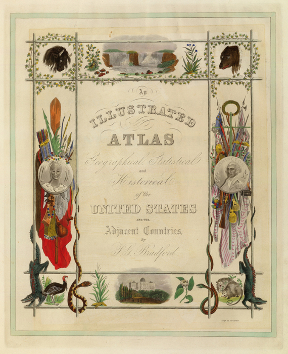
�������� : ���������������� �����, ��������������, �������������� � ������������, ����������� ������ ������� � ������������ �����
����� : �. Bradford ���� : 1838
2.
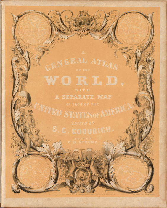
�������� : ����� ������������ Of The World, � ��������� ����� ������ �� ����������� ������ �������
����� : �. Bradford & SG Goodrich ���� : 1841
3.

�������� : ����� ����������� �����, ��������� � �����-������, ��������� ������� � �������, ����� ���� ��� � ������ �������������� ������������ ���� ��������� ����� ����; �������� � ��������� ��� ����� � ������������� ���������
����� : ����� Arrowsmith ���� : 1817

�������� : ����� ������������ De La France
����� : ������ �������� ���� : 1856
5.

Title: Atlas moderne ou collection de cartes sur toutes les parties du globe terrestre ar plusieurs auteurs Avec approbation & privilege du Roy. A Paris, Chez Lattre Graveur Ordinaire du Roy, de Mgr. Le Duc d'Orleans et de la Ville Rue St. Jacques No. 20. et Delalain Libraire, rue de la Comedie Francoise. Monnet del. 1762. Prevost Sculp. Pub Reference
Author: Ribogert Bonne & Jean Lattre
Date: 1791
6.

Title: A New General Atlas Comprising a Complete Set of Maps, representing the Grand Divisions Of The Globe, Together with the several Empires, Kingdoms, and States in the World; Compiled from the Best Authorities, and corrected by the Most Recent Discoveries
Author: Anthony Finley
Date: 1824
7.

Title: Atlas minor: or a new and curious set of sixty-two maps, in which are shewn all the empires, kingdoms, countries, states, in all the known parts of the earth; with their bounds, divisions, chief cities & towns, the whole composed & laid down agreable to modern history
Author: Thos. & John Bowles
Date: 1736
8.

Title: Atlas fisico y politico, Republica de Venezuela
Author: Agustin Coduzzi
Date: 1859
9.

Title: Atlas de Filipinas. Coleccion de 30 Mapas. Trabajados por delineantes filipinos bajo la direcion del P. Jose Algue, S.J., Director del Observatorio de Manila
Author: Jose PAlgue; U.S. Coast and Geodetic Survey
Date: 1899
10.

Title: A New Universal Atlas Containing Maps of the various Empires, Kingdoms, States and Republics Of The World. With a special map of each of the United States, Plans of Cities &c. Comprehended in seventy sheets and forming a series of One Hundred And Seventeen Maps, Plans And Sections
Author: HS Tanner
Date: 1836
11.

Title: Atlas classique et universel de geographie ancienne et moderne, contenant les decouvertes et les divisions les plus nouvelles dans les cinq parties du monde pour servir a la lecture des voyages, des ouvrages historiques et des meilleurs traites de geographie
Author: J Andriveau-Goujon
Date: 1850
12.

Title: An illustrated historical atlas of the State of Minnesota. {view of} Lake Emily, Minn. near St. Peter [Le Sueur Co.]
Author: AT Andreas
Date: 1874
13.

Title: Atlas du voyage de La Perouse
Author: Jean-Francois de Galaup, Comte de La Perouse
Date: 1797
14.

Title: An Illustrated Historical Atlas Of LaPorte Co. Indiana. Compiled Drawn & Published from Personal Examinations & Surveys by Higgins, Belden & Co.
Author: Higgins, Belden & Co.
Date: 1874
15.

Title: An Atlas of the World, Comprehending Separate Maps of its various Countries, Constructed & drawn from the latest Astronomical & Geographical Observations
Author: James Wyld
Date: 1864
16.

Title: Allgemeiner Schulatlas
Author: August Ruhle von Lilienstern
Date: 1825
17.

Title: An atlas of the State of New York, containing a map of the State and of the several counties ... under the superintendance & direction of Simeon DeWitt, Surveyor General, pursuant to an Act of the Legislature, and also the physical geography of the State & of the several counties & statistical tables of the same
Author: DH Burr
Date: 1829
18.

Title: Allgemeiner Hand-Atlas der Erde und des Himmels nach den besten astronomischen Bestimmungen, neuesten Entdeckungen und kritischen Untersuchungen entworfen
Author: Geographisches Institut (Weimar, Germany)
Date: 1856
19.

Title: A.T. Andreas' illustrated historical atlas of the State of Iowa.
Author: AT Andreas (Andreas Atlas Co.)
Date: 1875
20.

Title: A New American Atlas Containing Maps Of The Several States of the North American Union, Projected and drawn on a Uniform Scale from Documents found in the public Offices of the United States and State Governments, and other Original and Authentic Information
Author: HS Tanner
Date: 1823
21.

Title: A General Atlas, Of All The Known Countries In The World
Author: Fielding Lucas Jr.
Date: 1822
22.

Title: A General Atlas, Containing Maps illustrating some important periods in Ancient History; and distinct Maps of the several Empires, Kingdoms and States In The World, From Original Drawings according to the latest Treaties by J. Wyld and Engraved by N.R. Hewitt. Edinburgh, Printed for John Thomson & Co for Baldwin, Cradock & Joy, London & John Cumming, Dublin.
Author: James Wyld (nb. see above) & John Thompson
Date: 1824
23.

Title: (Half Title Page to) Johnson's New Illustrated (Steel Plate) Family Atlas, With Descriptions, Geographical, Statistical, And Historical. Compiled, Drawn, and Engraved Under The Supervision Of J.H. Colton And A.J. Johnson. New York
Author: AJ Johnson
Date: 1860
����� ��������� "����������, �������, �������":
����� 1 - ��������� ����� ������� � ������� � ���������� �� Rumsey Map Collection_����� 1
����� 2 - ��������� ����� ������� � ������� � ���������� �� Rumsey Map Collection_����� 2
����� 3 - ����������� ������� ���� 1763 ����
����� 4 - ��������� �������� � �������
...
����� 11 - ����������. ��������� ��������
����� 12 - �������� �����_���� � �������
����� 13 - Varin/People As Butterflies 1852
| �������: | �������� ��� ��������/������ |
| �������������� | « ����. ������ — � �������� — ����. ������ » | ��������: [1] [�����] |


