Добавить любой RSS - источник (включая журнал LiveJournal) в свою ленту друзей вы можете на странице синдикации.
Исходная информация - http://www.360cities.net/. Данный дневник сформирован из открытого RSS-источника по адресу http://www.360cities.net/rss/rss.xml, и дополняется в соответствии с дополнением данного источника. Он может не соответствовать содержимому оригинальной страницы. Трансляция создана автоматически по запросу читателей этой RSS ленты. По всем вопросам о работе данного сервиса обращаться со страницы контактной информации.[Обновить трансляцию]
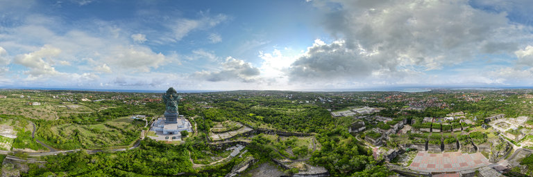
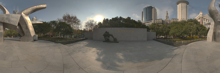
360° panorama by Fietter Chalim. Click the image to open the interactive version.
Garuda Wisnu Kencana Cultural Park (Indonesian: Taman Budaya Garuda Wisnu Kencana), or GWK, is a tourist destination and attraction located at Ungasan, Badung on the island of Bali, Indonesia about 10–15 minutes drive from Ngurah Rai International Airport. It is devoted to the Hindu god Vishnu, and his mount, Garuda, the mythical bird who became his companion.
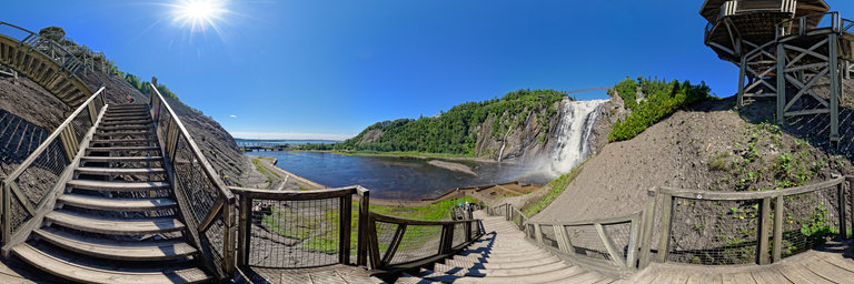
360° panorama by Brian Richards. Click the image to open the interactive version.
The falls are located on the boundary between the borough of Beauport, and Boischatel, about 12 km (7.5 mi) from the heart of old Quebec City. The area surrounding the falls is protected within the Montmorency Falls Park. The falls are at the mouth of the Montmorency River where it drops over the cliff shore into the Saint Lawrence River, opposite the western end of the ^Ile d'Orleans. The waterfalls are 83 m (272') tall, a full 30 m (99') higher than Niagara Falls. There are staircases that allow visitors to view the falls from several different perspectives. A suspension bridge over the crest of the falls provides access to both sides of the park. There is also a funitel that carries passengers between the base and the top of the falls. In the summer the park hosts an international fireworks competition with the falls as a backdrop. The Falls were the site of a key scene between the lead actors in the 1947 film Whispering City, which was filmed on location. In his poem "Sleep and Poetry" (1816), John Keats says that human life is "a poor Indian's sleep / While his boat hastens to the monstrous steep / Of Montmorency." Recreational sleighing on the frozen falls is recorded in Letitia Elizabeth Landon's poem The Montmorency Waterfall and Cone of 1835.
360° panorama by Brian Richards. Click the image to open the interactive version.
The Saguenay River is a major river of Quebec, Canada. It drains Lac Saint-Jean in the Laurentian Highlands, leaving at Alma and running east; the city of Saguenay is located on the river. It drains into the Saint Lawrence River. Tadoussac, founded as a French colonial trading post in 1600, is located on the northeast bank at this site. The river has a very high flow-rate and is bordered by steep cliffs associated with the Saguenay Graben. Tide waters flow in its fjord upriver as far as Chicoutimi (about 100 kilometres). Many Beluga whales breed in the cold waters at its mouth, making Tadoussac a popular site for whale watching and sea kayaking; Greenland sharks also frequent the depths of the river. The area of the confluence of the Saguenay and Saint Lawrence is protected by the Saguenay–St. Lawrence Marine Park, one of Canada's national parks.
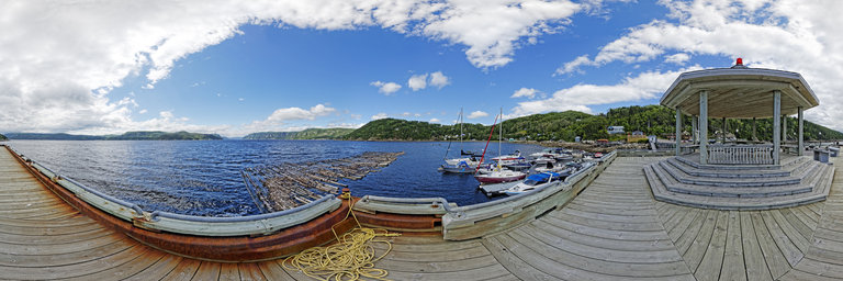
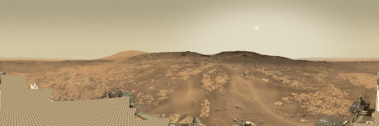
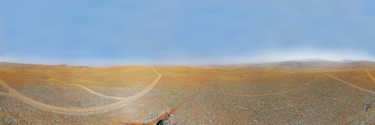
360° panorama by Andrew Bodrov. Click the image to open the interactive version.
NASA's Mars Exploration Program (Image credit: NASA/JPL-Caltech/MSSS) Sol 898: You do have the coolest job in the world The images for panorama obtained by the rover's 34-millimeter Mast Camera. The mosaic, which stretches about 30,000 pixels width, includes 136 images taken on Sol 898 (February 14, 2015). The planning day kicked off to a great start, with the SOWG Chair (Aileen Yingst) reminding us that we do have the coolest job in the world. I’m the Geology Theme Lead today, and it certainly feels like an exciting job. In this plan we’ve managed to use almost every instrument onboard the rover to characterize the most recent drill sample and the surrounding environment. First we’ll dump the post-sieve sample, and then we’ll "thwack" and vibrate CHIMRA (the Collection and Handling for in-Situ Martian Rock Analysis) to clean out any remnants of the sample. Later in the plan we’ll use MAHLI and APXS to characterize the grain size and composition of the dump pile, and Mastcam to document the pile with all of the camera filters. We’ll also use ChemCam to assess a nearby vein, and MAHLI will carry out some nighttime imaging of the drill hole and CheMin inlet. We don’t often mention it in our blogs, but every sol we’re also collecting RAD, REMS and DAN data for radiation assessment, environmental monitoring, and neutron detection. Meanwhile the SAM instrument is patiently waiting to analyze the samples that we "doggie bagged" a few sols ago. Lauren EdgarMSL Scientist Other panoramas of Mars by Curiosity rover: http://www.360cities.net/sets/curiosity-mars
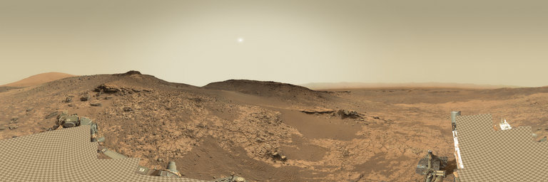
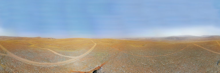
360° panorama by Andrew Bodrov. Click the image to open the interactive version.
NASA's Mars Exploration Program (Image credit: NASA/JPL-Caltech/MSSS) Sol 901: Long weekend, long plan! The images for panorama obtained by the rover's 34-millimeter Mast Camera. The mosaic, which stretches about 30,000 pixels width, includes 141 images taken on Sol 901 (February 17, 2015). Today we planned 4 sols to take the rover through President’s day weekend. We humans get a long weekend, but the rover has a lot of work to do! We were supposed to drive about 45 meters in the previous plan, but the data received this morning showed that the rover stopped after only 17 meters. I was on duty as the ChemCam science Payload Uplink Lead (sPUL) today, and in the science theme group meeting we were worried that the short drive would cause a major change in the plan, but it turned out not to be a problem. The rover drivers understand why the rover stopped early and had no concerns about simply continuing the drive in today’s plan. Even better, there was enough room in the plan to do the drive without changing how much time we had to do science! The location where the rover stopped was mostly flat bedrock and large sand ripples: not where we planned to stop, but still plenty of science to do. On sol 899, ChemCam will analyze the target "Osiris" and on Sol 900 ChemCam will analyze "Garley." Both of these targets are patches of bedrock, so the chemistry data, when combined with the many other observations of bedrock over the last few weeks and months, will help understand how the rocks change throughout the stratigraphic section. Mastcam has an 8x3 mosaic of Osiris on Sol 899, which seems to have some fine layering that is barely visible in Navcam. On sol 900 Mastcam also will take a documentation image of Garley, a 2x2 mosaic of a layered rock near the rover called "Sneakover" (because it was snuck into the plan at the last minute), and a 2x2 mosaic of "Hermosa," where the rover tracks cross a sand ripple. On sol 901, ChemCam will make some passive (no laser) measurements of the sky, and then Curiosity will resume the drive that was cut short. After the drive, we have standard imaging to get our bearings, plus a Mastcam 360 degree mosaic and a Navcam cloud observation. The DAN instrument will do an active measurement after the drive to characterize the amount of light elements (such as the hydrogen in water) under the rover in the new location. And finally, ChemCam will do some routine measurements of the calibration targets. On sol 902, the rover gets a bit of a rest, with just routine environmental measurements by RAD and REMS. Ryan AndersonPlanetary scientist at the USGS Astrogeology Science Center and a member of the ChemCam team on MSL Other panoramas of Mars by Curiosity rover: http://www.360cities.net/sets/curiosity-mars
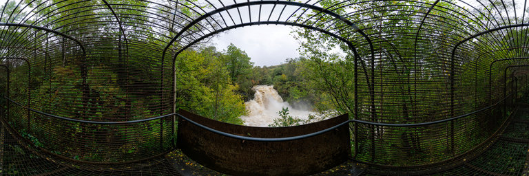
360° panorama by Gary Davies. Click the image to open the interactive version.
A scenic waterfall located close to the A82 in the Loch Lomond & The Trossachs National Park. The falls are best viewed from a metal caged viewing platform, called 'Woven Sound’.
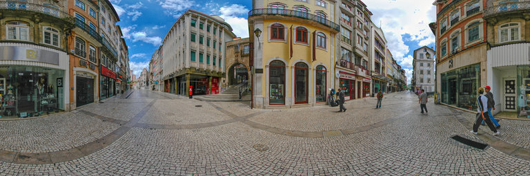
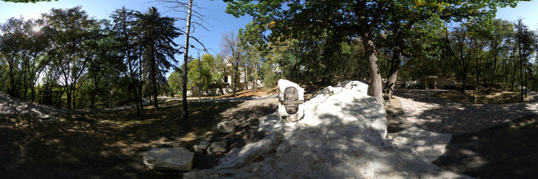
360° panorama by Santiago Ribas - 360portugal. Click the image to open the interactive version.
The Almedina Gate and Tower is accessed from the Barbac~a Gate, on Ferreira Borges Street, one of the main arteries in downtown Coimbra. Both are part of the Muralhada City Center. Based on the lowest part of the medieval fence, its construction can date back to the time of Count Sesnando Davides, who conquered Coimbra in 1064, having been renovated and remodeled over the centuries. This door was defended, primitively, by two advanced cubes that, later, were connected by means of a deep arch, over which the strong turret was raised. Its current aspect may be the result of a reform in the beginning of the 16th century, as determined by Manuel I of Portugal.