Добавить любой RSS - источник (включая журнал LiveJournal) в свою ленту друзей вы можете на странице синдикации.
Исходная информация - http://www.360cities.net/. Данный дневник сформирован из открытого RSS-источника по адресу http://www.360cities.net/rss/rss.xml, и дополняется в соответствии с дополнением данного источника. Он может не соответствовать содержимому оригинальной страницы. Трансляция создана автоматически по запросу читателей этой RSS ленты. По всем вопросам о работе данного сервиса обращаться со страницы контактной информации.[Обновить трансляцию]
360° panorama by RJ Wafer. Click the image to open the interactive version.
A sunny afternoon in July 2024 inside the park side of the Canada Gate, looking towards the Palace
360° panorama by RJ Wafer. Click the image to open the interactive version.
A sunny afternoon in July 2024 inside the park side of the Canada Gate, looking towards the Palace
360° panorama by Bill Landenberger. Click the image to open the interactive version.
This location at the end of King Trail, is part of the eastern section of the proposed Richmond Vale Rail Trail. While this is not part of the abandoned rail line, it will link with other cycleways and shared paths in Newcastle with Hexham via Pipeline Road and a bridge across Ironbark Creek, pictured here. It will then be part of a broader 'Shiraz to Shore' network of shared paths.
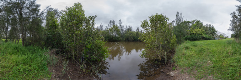
Воскресенье, 06 Октября 2024 г. 01:01
+ в цитатник
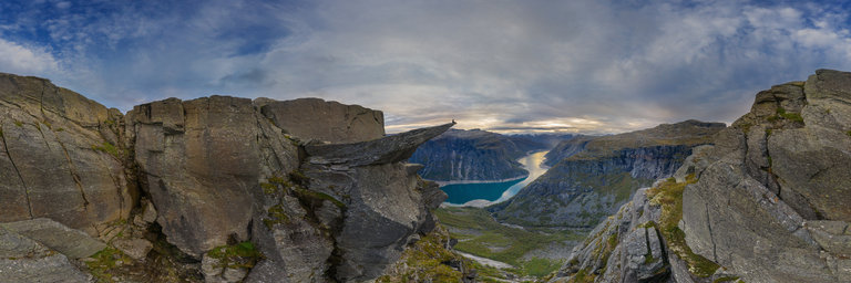
360° panorama by Andrew Bodrov. Click the image to open the interactive version.
Trolltunga is one of the most famous natural landmarks in Norway. This rock formation, resembling a "troll's tongue" rises 700 meters above Lake Ringedalsvatnet. It’s a popular tourist spot known for its breathtaking views of the mountains. The hike to Trolltunga is a challenging journey, covering 20 to 28 kilometers round trip and can take between 10 and 12 hours. However, it’s also one of the most photographed places in Norway, especially for those seeking spectacular panoramas.