Добавить любой RSS - источник (включая журнал LiveJournal) в свою ленту друзей вы можете на странице синдикации.
Исходная информация - http://www.360cities.net/. Данный дневник сформирован из открытого RSS-источника по адресу http://www.360cities.net/rss/rss.xml, и дополняется в соответствии с дополнением данного источника. Он может не соответствовать содержимому оригинальной страницы. Трансляция создана автоматически по запросу читателей этой RSS ленты. По всем вопросам о работе данного сервиса обращаться со страницы контактной информации.[Обновить трансляцию]
Воскресенье, 04 Декабря 2022 г. 00:17
+ в цитатник
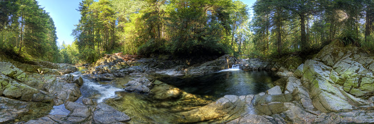
360° panorama by Robert Prior. Click the image to open the interactive version.
Chapman Creek reaches the Georgia Strait at Davis Bay in Sechelt and is thought to have been one of the largest salmon producing streams on the Sunshine Coast prior to European contact in the mid-1800s. According to the Strategic Land Use Plan for the shishalh Nation (Draft 2007) this watershed has significant spiritual and cultural importance. It is also the source of drinking water for approximately 27,000 people. The will of the shishalh people and the Sunshine Coast Regional District for the management of this watershed is expressed in the Joint Watershed Management Agreement of 2005. Since 1947, peak escapements for Coho, Pink and Steelhead have numbered in the hundreds. The peak number for Chum was 3500 spawners in 1973 and again in 1974. It is likely that the numbers for the Pink and Chum were much higher before the main creek mouth at the Wilson Creek estuary was diverted to its present outlet at Davis Bay in 1936. Between 1967 and 1992, extensive logging and road building over unstable slopes caused over 300 landslides and road failures which impacted both drinking water quality and fisheries values. An Integrated Watershed Management Plan (IWMP) was completed in 1998 but was never implemented. Chapman salmonids have also been negatively impacted by SCRD water withdrawals during late summer low flow periods. In 1999, a fish habitat and riparian assessment was conducted for the BC Ministry of Environment in conjunction with the Chapman Creek Watershed Restoration Project. A Coastal Watershed Assessment Procedure was completed by International Forest Products (Interfor) in 2000. It assessed the effects of past forest practices and provided recommendations for future forestry development. Also that year, Chapman Creek was one of only 15 streams designated as sensitive under the BC Fisheries Protection Act. Interfor abandoned this chart area in 2002. Rainbow Trout and Dolly Varden were introduced before records were kept; Coho and Cutthroat were stocked in the late 1980s. Beginning in the early 1990s the Sunshine Coast Salmon Enhancement Society stocked Pink, Chum, Coho, Cutthroat, Steelhead and introduced Chinook. The stocking of Cutthroat was discontinued to ensure the survival of salmon fry and smolts. The Greater Georgia Basin Steelhead Recovery Action Plan of 2002 identified the stock status of both winter and summer Steelhead runs as a special concern. In 2004, during an enumeration of the Steelhead a total of only 2 adult Cutthroat were observed. Chapman Creek is now regularly stocked with salmon fry. Returns have been disappointing and it is not clear that there are any wild self-sustaining salmon stocks left in this watershed. (From the Sunshine Coast Conservation Association.)
Воскресенье, 04 Декабря 2022 г. 00:17
+ в цитатник
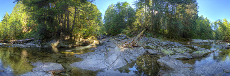
360° panorama by Robert Prior. Click the image to open the interactive version.
Chapman Creek reaches the Georgia Strait at Davis Bay in Sechelt and is thought to have been one of the largest salmon producing streams on the Sunshine Coast prior to European contact in the mid-1800s. According to the Strategic Land Use Plan for the shishalh Nation (Draft 2007) this watershed has significant spiritual and cultural importance. It is also the source of drinking water for approximately 27,000 people. The will of the shishalh people and the Sunshine Coast Regional District for the management of this watershed is expressed in the Joint Watershed Management Agreement of 2005. Since 1947, peak escapements for Coho, Pink and Steelhead have numbered in the hundreds. The peak number for Chum was 3500 spawners in 1973 and again in 1974. It is likely that the numbers for the Pink and Chum were much higher before the main creek mouth at the Wilson Creek estuary was diverted to its present outlet at Davis Bay in 1936. Between 1967 and 1992, extensive logging and road building over unstable slopes caused over 300 landslides and road failures which impacted both drinking water quality and fisheries values. An Integrated Watershed Management Plan (IWMP) was completed in 1998 but was never implemented. Chapman salmonids have also been negatively impacted by SCRD water withdrawals during late summer low flow periods. In 1999, a fish habitat and riparian assessment was conducted for the BC Ministry of Environment in conjunction with the Chapman Creek Watershed Restoration Project. A Coastal Watershed Assessment Procedure was completed by International Forest Products (Interfor) in 2000. It assessed the effects of past forest practices and provided recommendations for future forestry development. Also that year, Chapman Creek was one of only 15 streams designated as sensitive under the BC Fisheries Protection Act. Interfor abandoned this chart area in 2002. Rainbow Trout and Dolly Varden were introduced before records were kept; Coho and Cutthroat were stocked in the late 1980s. Beginning in the early 1990s the Sunshine Coast Salmon Enhancement Society stocked Pink, Chum, Coho, Cutthroat, Steelhead and introduced Chinook. The stocking of Cutthroat was discontinued to ensure the survival of salmon fry and smolts. The Greater Georgia Basin Steelhead Recovery Action Plan of 2002 identified the stock status of both winter and summer Steelhead runs as a special concern. In 2004, during an enumeration of the Steelhead a total of only 2 adult Cutthroat were observed. Chapman Creek is now regularly stocked with salmon fry. Returns have been disappointing and it is not clear that there are any wild self-sustaining salmon stocks left in this watershed. (From the Sunshine Coast Conservation Association.)
Воскресенье, 04 Декабря 2022 г. 00:17
+ в цитатник
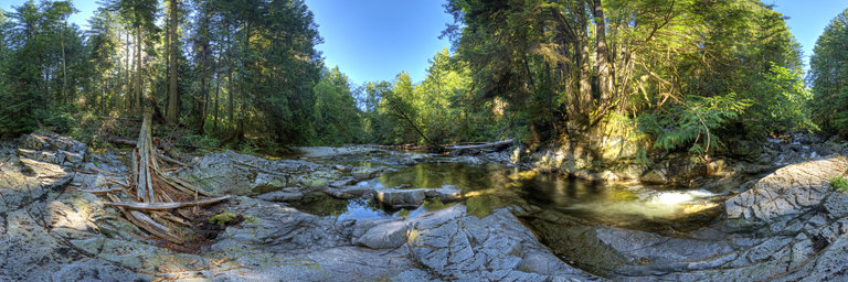
360° panorama by Robert Prior. Click the image to open the interactive version.
Chapman Creek reaches the Georgia Strait at Davis Bay in Sechelt and is thought to have been one of the largest salmon producing streams on the Sunshine Coast prior to European contact in the mid-1800s. According to the Strategic Land Use Plan for the shishalh Nation (Draft 2007) this watershed has significant spiritual and cultural importance. It is also the source of drinking water for approximately 27,000 people. The will of the shishalh people and the Sunshine Coast Regional District for the management of this watershed is expressed in the Joint Watershed Management Agreement of 2005. Since 1947, peak escapements for Coho, Pink and Steelhead have numbered in the hundreds. The peak number for Chum was 3500 spawners in 1973 and again in 1974. It is likely that the numbers for the Pink and Chum were much higher before the main creek mouth at the Wilson Creek estuary was diverted to its present outlet at Davis Bay in 1936. Between 1967 and 1992, extensive logging and road building over unstable slopes caused over 300 landslides and road failures which impacted both drinking water quality and fisheries values. An Integrated Watershed Management Plan (IWMP) was completed in 1998 but was never implemented. Chapman salmonids have also been negatively impacted by SCRD water withdrawals during late summer low flow periods. In 1999, a fish habitat and riparian assessment was conducted for the BC Ministry of Environment in conjunction with the Chapman Creek Watershed Restoration Project. A Coastal Watershed Assessment Procedure was completed by International Forest Products (Interfor) in 2000. It assessed the effects of past forest practices and provided recommendations for future forestry development. Also that year, Chapman Creek was one of only 15 streams designated as sensitive under the BC Fisheries Protection Act. Interfor abandoned this chart area in 2002. Rainbow Trout and Dolly Varden were introduced before records were kept; Coho and Cutthroat were stocked in the late 1980s. Beginning in the early 1990s the Sunshine Coast Salmon Enhancement Society stocked Pink, Chum, Coho, Cutthroat, Steelhead and introduced Chinook. The stocking of Cutthroat was discontinued to ensure the survival of salmon fry and smolts. The Greater Georgia Basin Steelhead Recovery Action Plan of 2002 identified the stock status of both winter and summer Steelhead runs as a special concern. In 2004, during an enumeration of the Steelhead a total of only 2 adult Cutthroat were observed. Chapman Creek is now regularly stocked with salmon fry. Returns have been disappointing and it is not clear that there are any wild self-sustaining salmon stocks left in this watershed. (From the Sunshine Coast Conservation Association.)
Воскресенье, 04 Декабря 2022 г. 00:17
+ в цитатник
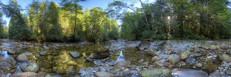
360° panorama by Robert Prior. Click the image to open the interactive version.
Chapman Creek reaches the Georgia Strait at Davis Bay in Sechelt and is thought to have been one of the largest salmon producing streams on the Sunshine Coast prior to European contact in the mid-1800s. According to the Strategic Land Use Plan for the shishalh Nation (Draft 2007) this watershed has significant spiritual and cultural importance. It is also the source of drinking water for approximately 27,000 people. The will of the shishalh people and the Sunshine Coast Regional District for the management of this watershed is expressed in the Joint Watershed Management Agreement of 2005. Since 1947, peak escapements for Coho, Pink and Steelhead have numbered in the hundreds. The peak number for Chum was 3500 spawners in 1973 and again in 1974. It is likely that the numbers for the Pink and Chum were much higher before the main creek mouth at the Wilson Creek estuary was diverted to its present outlet at Davis Bay in 1936. Between 1967 and 1992, extensive logging and road building over unstable slopes caused over 300 landslides and road failures which impacted both drinking water quality and fisheries values. An Integrated Watershed Management Plan (IWMP) was completed in 1998 but was never implemented. Chapman salmonids have also been negatively impacted by SCRD water withdrawals during late summer low flow periods. In 1999, a fish habitat and riparian assessment was conducted for the BC Ministry of Environment in conjunction with the Chapman Creek Watershed Restoration Project. A Coastal Watershed Assessment Procedure was completed by International Forest Products (Interfor) in 2000. It assessed the effects of past forest practices and provided recommendations for future forestry development. Also that year, Chapman Creek was one of only 15 streams designated as sensitive under the BC Fisheries Protection Act. Interfor abandoned this chart area in 2002. Rainbow Trout and Dolly Varden were introduced before records were kept; Coho and Cutthroat were stocked in the late 1980s. Beginning in the early 1990s the Sunshine Coast Salmon Enhancement Society stocked Pink, Chum, Coho, Cutthroat, Steelhead and introduced Chinook. The stocking of Cutthroat was discontinued to ensure the survival of salmon fry and smolts. The Greater Georgia Basin Steelhead Recovery Action Plan of 2002 identified the stock status of both winter and summer Steelhead runs as a special concern. In 2004, during an enumeration of the Steelhead a total of only 2 adult Cutthroat were observed. Chapman Creek is now regularly stocked with salmon fry. Returns have been disappointing and it is not clear that there are any wild self-sustaining salmon stocks left in this watershed. (From the Sunshine Coast Conservation Association.)
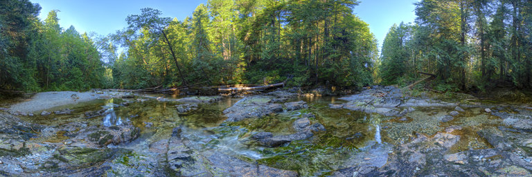
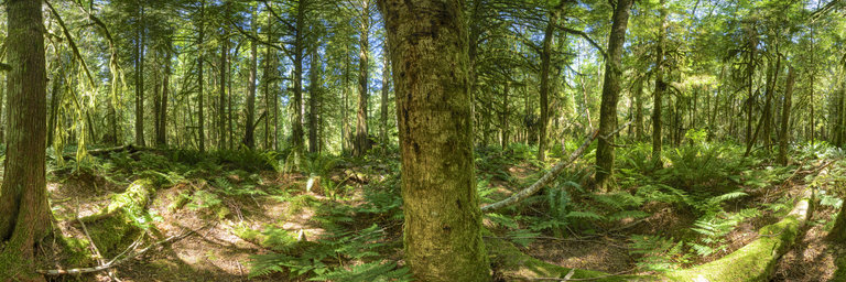
360° panorama by Robert Prior. Click the image to open the interactive version.
The Rainforest Coast of British Columbia encompasses the largest remaining intact temperate rainforest in the world. While it is often the beauty of BC’s coastal rainforests which enthral visitors from throughout the world, it is the productiveness of these forests that intrigue scientists. BC’s coastal rainforests feature the highest biomass (the total amount or mass of organisms in a given area) per hectare of any ecosystem on earth. Trees here can often live more than 1,000 years, reaching hundreds of feet into the air, with diameters exceeding 9.4m. Coastal rainforests provide critical habitat for incredibly varied populations of animals. Well-known species include grizzly bears, eagles, and the rare Kermode or Spirit bear, an unusual snow-white variation of the black bear. The coastal rainforests are among the rarest and most productive ecosystems on the planet; they are also disappearing before we know almost anything about them. It’s as if we are burning the library before we have read the books. Only in the last 10 years have scientists begun to learn about the fragile system of interrelationships that makes up the beautiful web of life in these “green cathedrals”. In the meantime salmon, which our fisheries as well as a multitude of other animals depend upon, are disappearing forever along with many other species that can live only in coastal rainforests. The temperate rainforest is very rare, originally covering less than 0.2% of the earth's land surface. Now, over one half of that limited original temperate rainforest has been logged and altered; of that which remains worldwide, over one quarter is found on BC's coast. Recently environmental organizations have been able to turn the spotlight of international concern to BC’s rainforests. Efforts to protect such ‘Great Spaces’ as the Kitlope and Great Bear Wilderness, have become internationally known as have the Queen Charlotte Islands’ Gwaii Haanas, and the Walbran Valley. But time is running out. So far only 5.8% of BC’s ancient rainforests have been protected and much of the rest has been scheduled to be clearcut in the next decade. (From the Spaces for Nature website.) This forest along Chapman Creek was logged (by hand) about a century ago. You can still see notched stumps scattered through the forest, with new trees sprouting from their tops.
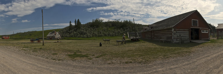
360° panorama by Robert Prior. Click the image to open the interactive version.
The Bar U Ranch is the only Parks Canada-administered National Historic Site that commemorates the importance of ranching to Canada. Founded in 1882 as the Northwest Cattle Company, the Bar U was one of the first and most enduring of the large corporate ranches established in southern Alberta. Three key personalities guided the ranch through seven decades of change up to 1950: Fred Stimson set the foundation and infrastructure for the Bar U Ranch, which under George Lane achieved international repute as a centre of breeding excellence for cattle and purebred Percheron horses. Patrick Burns and his company modernized the ranch by replacing horses with tractors and streamlined operations which took the Bar U though the depression and World War II. Explore one of the largest collections of original buildings in Canada. Treasures include the blacksmith shop, harness repair shop, roundup camp and saddlehorse barn. Taste the freshly-baked cookies at the cookhouse, hear the clattering hooves of our Percheron team and smell the cowboy coffee roasting over an open fire. Experience life on the ranch from 100 years ago. Learn more about the ranch at the official web site.
360° panorama by Gregory Perez. Click the image to open the interactive version.
The Courthouse in El Dorado Kansas, decorated for the holidays. December 2022
360° panorama by Gregory Perez. Click the image to open the interactive version.
The Courthouse in El Dorado Kansas, decorated for the holidays. December 2022
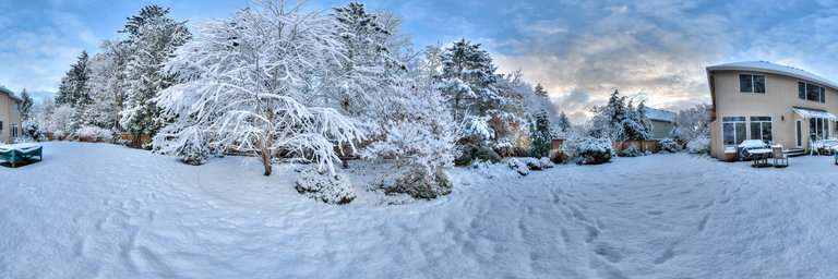
360° panorama by Bill Edwards. Click the image to open the interactive version.
It’s an early snow day on the very first of December. The overnight snowflakes that cloak the garden create a sense of ephemeral enchantment and magic. The branches of the Cercidyphyllum japonicum, our katsura tree, look especially maginificent enrobed in white.
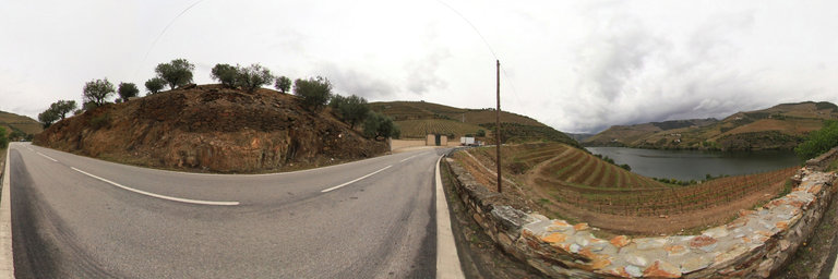
360° panorama by Isabel Marques. Click the image to open the interactive version.
The Alto Douro Vinhateiro or Douro Demarcated Region is the oldest wine-growing region in the world. It is an area in northeastern Portugal classified by UNESCO as a World Heritage Site in the category of cultural landscape. This cultural landscape of the Alto Douro combines the monumental nature of the Douro river valley, and its tributaries, T'avora, Tedo, Torto, Corgo, among others, made of steep slopes and rugged soils, with the ancestral and continuous action of Man, adapting the space to the Mediterranean-type agricultural needs that the region supports. The intimate relationship between human activity and nature has created an ecosystem of unique value, where the characteristics of the terrain are used in an exemplary way, with the modeling of the landscape in terraces, preserving it from erosion and allowing the cultivation of vines. In 1756 Marqu^es de Pombal, with a futuristic vision, created the Companhia Geral da Agricultura das Vinhas do Alto Douro and the Douro Demarcated Region, becoming the first demarcated and regulated wine region in the world. This region, which covers a vast area, extends along the Douro River and its tributaries, from Serra do Mar~ao and Montemuro to Barca de Alva, passing through S~ao Jo~ao da Pesqueira, the municipality of Alto Douro Vinhateiro, which has the largest area classified as world heritage by Unesco. The result in the Alto Douro Wine Region is a truly inspiring terraced setting. The region that has been producing wines for over 2,000 years, with Port Wine standing out among them, is a unique landscape in the world. This panorama was photographed on the side of the N222, one of the most beautiful roads that wind through the incredible Douro wine region, close to Quinta do Seixo / Sandeman where you can observe the landscape in terraces right next to the Douro River.
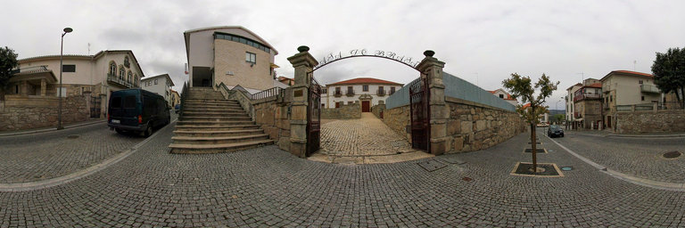
360° panorama by Isabel Marques. Click the image to open the interactive version.
Coat of Arms House or Casa do Bras~ao is a 17th-century mansion located on the main street of Tabuaco. The house still preserves details of the original building, including a stone coat of arms, a wooden staircase and decorated ceilings. It is an excellent example of Portuguese mannerism. Today, Casa do Bras~ao, is transformed into local accommodation, in the Douro wine region, the Alto Douro Vinhateiro.
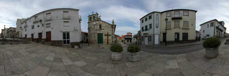
360° panorama by Isabel Marques. Click the image to open the interactive version.
The Main Church of Tabuaco, built in Baroque style, is located in Largo 5 de Outubro in the center of Tabuaco. Of Romanesque origin, it has a longitudinal plan and comprises a nave, chancel, side chapel and sacristy. The interior has a high choir and the main altarpiece is made of gilded carving in the national Baroque style. In the main church, invoking Nossa Senhora da Conceic~ao, it is worth noting its facade, the two-bell tower and the extremely rich baroque altarpiece in the chancel. It was built in the century. XVII and several renovations took place during the 18th, 19th and 20th centuries.
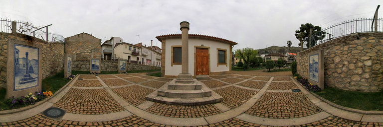
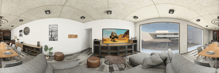
360° panorama by Isabel Marques. Click the image to open the interactive version.
It is a small garden in the center of the village of Tabuaco. A pleasant place with leafy trees and beautiful flowers where you can enjoy good times. It is in this garden that the Tourist Office of Tabuaco is located, where the Rijomax clock is located. A watch invented and built by Am^andio Jos'e Ribeiro, who considered it to be the “most complete watch in the world”. It was built between 1945 and 1973 and gained worldwide fame, entered the Guinness Book of Records and has patent number 12931. More information at https://www.cm-tabuaco.pt/ It is also here that a small square is located, Praca do Pelourinho, where some pillories from the municipality are also represented, in painted tiles, as can be seen in this panorama.