Добавить любой RSS - источник (включая журнал LiveJournal) в свою ленту друзей вы можете на странице синдикации.
Исходная информация - http://www.360cities.net/. Данный дневник сформирован из открытого RSS-источника по адресу http://www.360cities.net/rss/rss.xml, и дополняется в соответствии с дополнением данного источника. Он может не соответствовать содержимому оригинальной страницы. Трансляция создана автоматически по запросу читателей этой RSS ленты. По всем вопросам о работе данного сервиса обращаться со страницы контактной информации.[Обновить трансляцию]
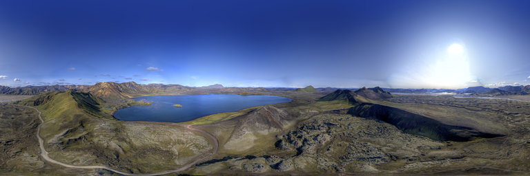
360° panorama by Robert Prior. Click the image to open the interactive version.
Hovering above Stutur (spout), an old volcanic cone inside an older volcanic cone near Landmannalaugar in Iceland. In the distance you can see the lake Frostastadavatn with the N'amshraun lava flow forming a peninsula. Landmannalaugar is a natural wonder situated in the colorful rhyolite mountains of Fjallabak Nature Reserve. The region is known for its soothing hot springs, brightly colored peaks, steam plumes, and clear blue lakes. The hot pools at Landmannalaugar are one of many manifestations of geothermal activity in the area, which also tends to alter the minerals in the rocks, causing the beautiful colour variations from red and yellow to blue and green, a good example being Brennisteinsalda. The Fjallabak Nature Reserve was established in 1979, covering 47,000 hectares. The land is mountainous, sculptured by volcanoes and geothermal activity, covered by lavas, sands, rivers and lakes. It takes its name from the numerous wild and rugged mountains with deeply incised valleys, which are found there. The topography of the Torfajokull, central volcano found within the reserve, is a result of the region being the largest rhyolite area in Iceland and the largest geothermal area (after Grimsvotn in Vatnajokull). Volcanic activity in the last 10,000 years has been restricted to a few fissures. The most recent one, the Veidivotn fissure from 1480, formed Laugahraun, Namshraun, Nordurnamshraun, Ljotipollur and other craters which extend 30 km further to the north. Eruptions in the area tend to be explosive and occur every 500-800 years, previous known eruptions being around AD 150 and 900.
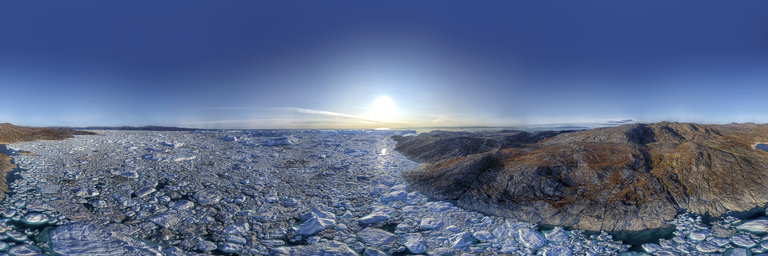
360° panorama by Robert Prior. Click the image to open the interactive version.
Located on the west coast of Greenland, 250 km north of the Arctic Circle, Greenland’s Ilulissat Icefjord is the sea mouth of Sermeq Kujalleq, one of the few glaciers through which the Greenland ice cap reaches the sea. Sermeq Kujalleq is one of the fastest and most active glaciers in the world. It annually calves over 35 cubic kilometres of ice — 10% of the production of all Greenland calf ice and more than any other glacier outside Antarctica. Studied for over 250 years, it has helped to develop our understanding of climate change and icecap glaciology. The combination of a huge ice-sheet and the dramatic sounds of a fast-moving glacial ice-stream calving into a fjord covered by icebergs makes for a dramatic and awe-inspiring natural phenomenon.
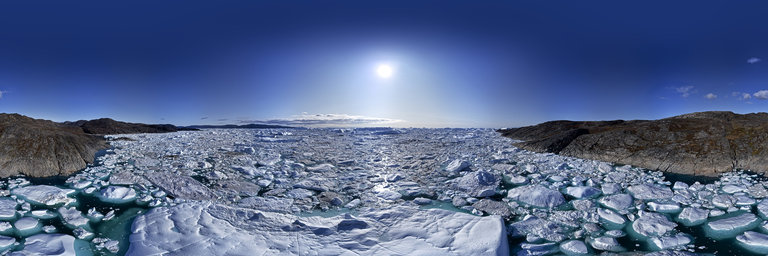
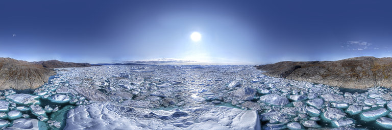
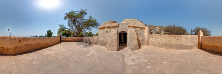
360° panorama by shahid adam. Click the image to open the interactive version.
One of the oldest mosques in the UAE, The oldest surviving mosque in the UAE has mysterious origins and unusual architecture, located in fujairah UAE
360° panorama by shahid adam. Click the image to open the interactive version.
One of the oldest mosques in the UAE, The oldest surviving mosque in the UAE has mysterious origins and unusual architecture, located in fujairah UAE