Добавить любой RSS - источник (включая журнал LiveJournal) в свою ленту друзей вы можете на странице синдикации.
Исходная информация - http://www.360cities.net/. Данный дневник сформирован из открытого RSS-источника по адресу http://www.360cities.net/rss/rss.xml, и дополняется в соответствии с дополнением данного источника. Он может не соответствовать содержимому оригинальной страницы. Трансляция создана автоматически по запросу читателей этой RSS ленты. По всем вопросам о работе данного сервиса обращаться со страницы контактной информации.[Обновить трансляцию]
Понедельник, 08 Августа 2022 г. 11:15
+ в цитатник
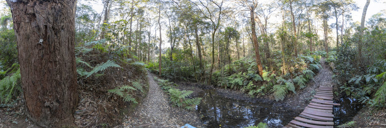
360° panorama by Bill Landenberger. Click the image to open the interactive version.
In the upper reaches of Kaiyutibbin Creek in George McGregor Park, the vegetation becomes rainforest like. This small footbridge forms park of a network of walking tracks in the park. A bonus feature in this panorama is a very large (dead) huntsman spider on the bark of the closest tree in the panorama.
Понедельник, 08 Августа 2022 г. 00:49
+ в цитатник
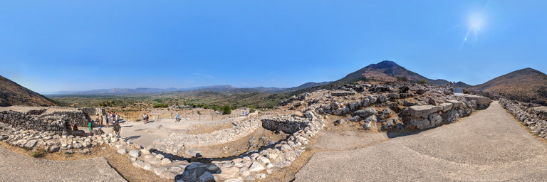
360° panorama by Nikos Maretas. Click the image to open the interactive version.
Mycenae is an archaeological site near Mykines in Argolis, north-eastern Peloponnese, Greece. It is located about 120 kilometres (75 miles) south-west of Athens; 11 kilometres (7 miles) north of Argos; and 48 kilometres (30 miles) south of Corinth. The site is 19 kilometres (12 miles) inland from the Saronic Gulf and built upon a hill rising 900 feet (274 metres) above sea level. In the second millennium BC, Mycenae was one of the major centres of Greek civilization, a military stronghold which dominated much of southern Greece, Crete, the Cyclades and parts of southwest Anatolia. The period of Greek history from about 1600 BC to about 1100 BC is called Mycenaean in reference to Mycenae. At its peak in 1350 BC, the citadel and lower town had a population of 30,000 and an area of 32 hectares. The first correct identification of Mycenae in modern literature was during a survey conducted by Francesco Grimani, commissioned by the Provveditore Generale of the Kingdom of the Morea in 1700, who used Pausanias's description of the Lion Gate to identify the ruins of Mycenae. This panorama was taken inside the actual palace of the complex that is the site. source: https://en.wikipedia.org/wiki/Mycenae
Понедельник, 08 Августа 2022 г. 00:49
+ в цитатник
360° panorama by Nikos Maretas. Click the image to open the interactive version.
Mycenae is an archaeological site near Mykines in Argolis, north-eastern Peloponnese, Greece. It is located about 120 kilometres (75 miles) south-west of Athens; 11 kilometres (7 miles) north of Argos; and 48 kilometres (30 miles) south of Corinth. The site is 19 kilometres (12 miles) inland from the Saronic Gulf and built upon a hill rising 900 feet (274 metres) above sea level. In the second millennium BC, Mycenae was one of the major centres of Greek civilization, a military stronghold which dominated much of southern Greece, Crete, the Cyclades and parts of southwest Anatolia. The period of Greek history from about 1600 BC to about 1100 BC is called Mycenaean in reference to Mycenae. At its peak in 1350 BC, the citadel and lower town had a population of 30,000 and an area of 32 hectares. The first correct identification of Mycenae in modern literature was during a survey conducted by Francesco Grimani, commissioned by the Provveditore Generale of the Kingdom of the Morea in 1700, who used Pausanias's description of the Lion Gate to identify the ruins of Mycenae. This panorama was taken inside the actual palace of the complex that is the site. source: https://en.wikipedia.org/wiki/Mycenae
Понедельник, 08 Августа 2022 г. 00:29
+ в цитатник
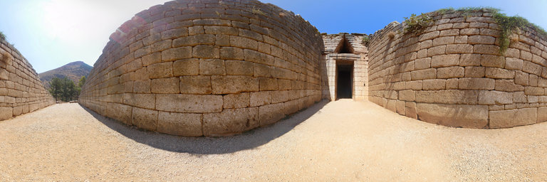
360° panorama by Nikos Maretas. Click the image to open the interactive version.
The Treasury of Atreus or Tomb of Agamemnon is a large tholos or beehive tomb on Panagitsa Hill at Mycenae, Greece, constructed during the Bronze Age around 1250 BC. The stone lintel above the doorway weighs 120 tons, with approximate dimensions 8.3 x 5.2 x 1.2m, the largest in the world. The tomb was used for an unknown period. Mentioned by the Roman geographer Pausanias in the 2nd century AD, it was still visible in 1879 when the German archaeologist Heinrich Schliemann discovered the shaft graves under the "agora" in the Acropolis at Mycenae. The tomb perhaps held the remains of the sovereign who completed the reconstruction of the fortress or one of his successors. The grave is in the style of the other tholoi of Mycenaean Greece, of which there are nine in total around the citadel of Mycenae and many more in the Argolid. However, in its monumental shape and grandeur it is one of the most impressive monuments surviving from the Mycenaean period. The tomb has probably no relationship with either Atreus or Agamemnon – legendary rulers of Mycenae or Argos in the works of Homer, in the Epic Cycle, and the Oresteia – as archaeologists believe that the Mycenaean sovereign buried there ruled at an earlier date than the king; it was named thus by Heinrich Schliemann and the name has been used ever since.The historicity of the Trojan War, to which Schliemann sought to connect both Mycenae and Hisarlik, is a matter of long-standing and ongoing debate. source: https://en.wikipedia.org/wiki/Treasury_of_Atreus
Понедельник, 08 Августа 2022 г. 00:29
+ в цитатник
360° panorama by Nikos Maretas. Click the image to open the interactive version.
The Treasury of Atreus or Tomb of Agamemnon is a large tholos or beehive tomb on Panagitsa Hill at Mycenae, Greece, constructed during the Bronze Age around 1250 BC. The stone lintel above the doorway weighs 120 tons, with approximate dimensions 8.3 x 5.2 x 1.2m, the largest in the world. The tomb was used for an unknown period. Mentioned by the Roman geographer Pausanias in the 2nd century AD, it was still visible in 1879 when the German archaeologist Heinrich Schliemann discovered the shaft graves under the "agora" in the Acropolis at Mycenae. The tomb perhaps held the remains of the sovereign who completed the reconstruction of the fortress or one of his successors. The grave is in the style of the other tholoi of Mycenaean Greece, of which there are nine in total around the citadel of Mycenae and many more in the Argolid. However, in its monumental shape and grandeur it is one of the most impressive monuments surviving from the Mycenaean period. The tomb has probably no relationship with either Atreus or Agamemnon – legendary rulers of Mycenae or Argos in the works of Homer, in the Epic Cycle, and the Oresteia – as archaeologists believe that the Mycenaean sovereign buried there ruled at an earlier date than the king; it was named thus by Heinrich Schliemann and the name has been used ever since.The historicity of the Trojan War, to which Schliemann sought to connect both Mycenae and Hisarlik, is a matter of long-standing and ongoing debate. source: https://en.wikipedia.org/wiki/Treasury_of_Atreus
Понедельник, 08 Августа 2022 г. 00:16
+ в цитатник
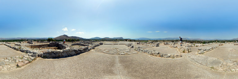
360° panorama by Nikos Maretas. Click the image to open the interactive version.
Tiryns is a Mycenaean archaeological site in Argolis in the Peloponnese, and the location from which the mythical hero Heracles performed his Twelve Labours. It lies 20 kilometers south of Mycenae. Tiryns was a hill fort with occupation ranging back seven thousand years, from before the beginning of the Bronze Age. It reached its height of importance between 1400 and 1200 BC, when it became one of the most important centers of the Mycenaean world, and in particular in Argolis. Its most notable features were its palace, its Cyclopean tunnels and especially its walls, which gave the city its Homeric epithet of "mighty walled Tiryns". Tiryns became associated with the myths surrounding Heracles, as the city was the residence of the hero during his labors, and some sources cite it as his birthplace. The famous megaron of the palace of Tiryns has a large reception hall, the main room of which had a throne placed against the right wall and a central hearth bordered by four Minoan-style wooden columns that served as supports for the roof. Two of the three walls of the megaron were incorporated into an archaic temple of Hera. The site went into decline at the end of the Mycenaean period, and was completely deserted by the time Pausanias visited in the 2nd century AD. In 1300 BC the citadel and lower town had a population of 10,000 people covering 20–25 hectares. Despite the destruction of the palace in 1200 BC, the city population continued to increase and by 1150 BC it had a population of 15,000 people. UNESCO designated Tiryns as a World Heritage Site in 1999. source:https://en.wikipedia.org/wiki/Tiryns
Понедельник, 08 Августа 2022 г. 00:16
+ в цитатник
360° panorama by Nikos Maretas. Click the image to open the interactive version.
Tiryns is a Mycenaean archaeological site in Argolis in the Peloponnese, and the location from which the mythical hero Heracles performed his Twelve Labours. It lies 20 kilometers south of Mycenae. Tiryns was a hill fort with occupation ranging back seven thousand years, from before the beginning of the Bronze Age. It reached its height of importance between 1400 and 1200 BC, when it became one of the most important centers of the Mycenaean world, and in particular in Argolis. Its most notable features were its palace, its Cyclopean tunnels and especially its walls, which gave the city its Homeric epithet of "mighty walled Tiryns". Tiryns became associated with the myths surrounding Heracles, as the city was the residence of the hero during his labors, and some sources cite it as his birthplace. The famous megaron of the palace of Tiryns has a large reception hall, the main room of which had a throne placed against the right wall and a central hearth bordered by four Minoan-style wooden columns that served as supports for the roof. Two of the three walls of the megaron were incorporated into an archaic temple of Hera. The site went into decline at the end of the Mycenaean period, and was completely deserted by the time Pausanias visited in the 2nd century AD. In 1300 BC the citadel and lower town had a population of 10,000 people covering 20–25 hectares. Despite the destruction of the palace in 1200 BC, the city population continued to increase and by 1150 BC it had a population of 15,000 people. UNESCO designated Tiryns as a World Heritage Site in 1999. source:https://en.wikipedia.org/wiki/Tiryns
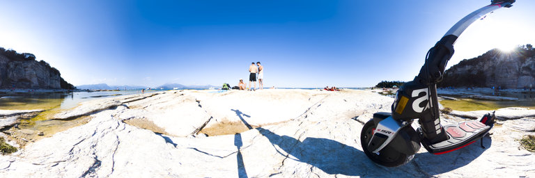
Воскресенье, 07 Августа 2022 г. 14:52
+ в цитатник
360° panorama by Mariano Caffaro. Click the image to open the interactive version.
Aprilia eSR1 La mobilit`a elettrica non rinuncia all’impronta sportiva
Воскресенье, 07 Августа 2022 г. 14:52
+ в цитатник
360° panorama by Mariano Caffaro. Click the image to open the interactive version.
Aprilia eSR1 La mobilit`a elettrica non rinuncia all’impronta sportiva
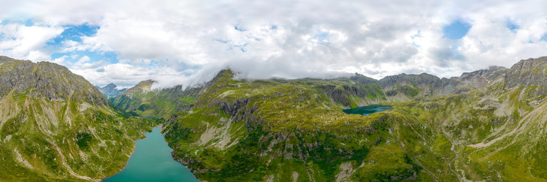
Воскресенье, 07 Августа 2022 г. 00:37
+ в цитатник
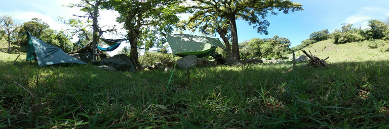
360° panorama by Bill Edwards. Click the image to open the interactive version.
This boulder field vista was taken on the Pacific Crest Trail on the southern flank of Alaska Mountain. The day prior, we hiked from the Snoqualmie Pass Trailhead, across the Kendall Katwalk to Ridge Lake where we camped overnight. The weather was completely socked in with no views, and no 360 opportunities. Fortunately, we awoke to sunny skies with spectacular clouds. We then hiked another 1.5 miles north to the toe of the east ridge of Alaska Mountain for a possible summit scramble. It seemed too steep and sketchy, so we bagged that plan. I set up my tripod in this boulder field, which looks south towards the glacier-covered massif of Mt. Rainier on the distant skyline. The nearby summit of Mt. Thomson is visible above the tree line to the north. This section of the PCT is considered one of the most spectacular due to the dramatic mountain terrain.