Добавить любой RSS - источник (включая журнал LiveJournal) в свою ленту друзей вы можете на странице синдикации.
Исходная информация - http://www.360cities.net/. Данный дневник сформирован из открытого RSS-источника по адресу http://www.360cities.net/rss/rss.xml, и дополняется в соответствии с дополнением данного источника. Он может не соответствовать содержимому оригинальной страницы. Трансляция создана автоматически по запросу читателей этой RSS ленты. По всем вопросам о работе данного сервиса обращаться со страницы контактной информации.[Обновить трансляцию]
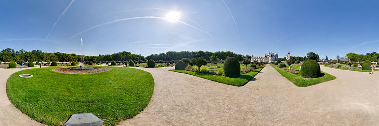
360° panorama by Brian Richards. Click the image to open the interactive version.
The Ch^ateau de Chenonceau is a Loire castle located in Touraine , in the commune of Chenonceaux , in the department of Indre-et-Loire in the Center-Val de Loire region. Chenonceau with its famous two-storey gallery which dominates the Cher is one of the jewels of the architecture of the Loire Valley. Its borrowings from Italy and its French characteristics are clearly noticeable. Chenonceau is built, fitted out and transformed by women who are very different in their temperament. It was built by Katherine Briconnet in 1513, enriched by Diane de Poitiers and enlarged under Catherine de M'edicis . It becomes a place of contemplation with the white queen Louise of Lorraine , then it is saved by Louise Dupin during the French Revolution and finally, metamorphosed by Madame Pelouze . Due to the large number of female personalities who have been in charge of it, it is nicknamed "the Ladies' Castle". The private domain of Chenonceau has belonged to the Menier family since 1913 and is open to visitors. The castle has been classified as a historical monument since its inclusion on the 1840 list and the park by decree dated 7 novembre 1962. The building and its environment are integrated in the Loire Valley , classified as World Heritage of Unesco , since July 9, 2017.
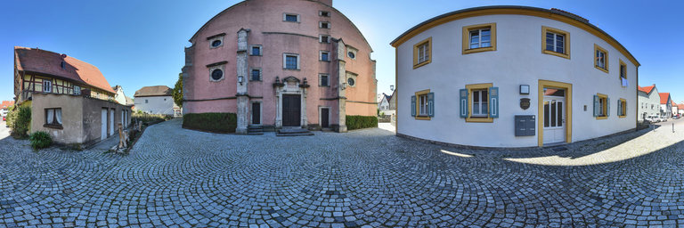
360° panorama by Ackermann Ralf. Click the image to open the interactive version.
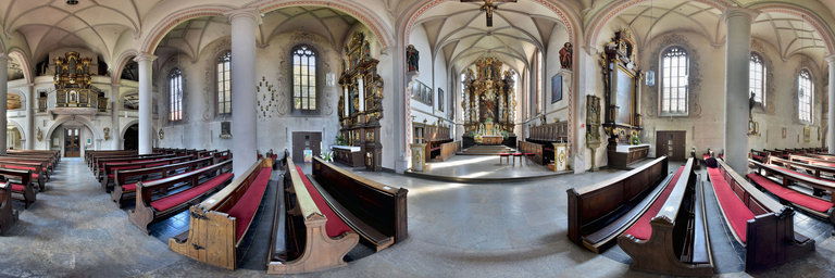
The parish church of St. Nicholas in Eibelstadt is located on the Franconian-Swabian Way of St. James, which leads from W"urzburg via Rothenburg ob der Tauber to Ulm. The distance is about 270 km and is marked with the symbol of the scallop. We are here in front of the west facade of the parish church. The rectory is on the right.
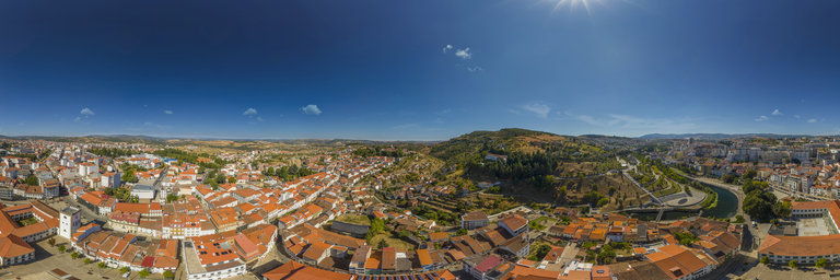
360° panorama by Santiago Ribas - 360portugal. Click the image to open the interactive version.
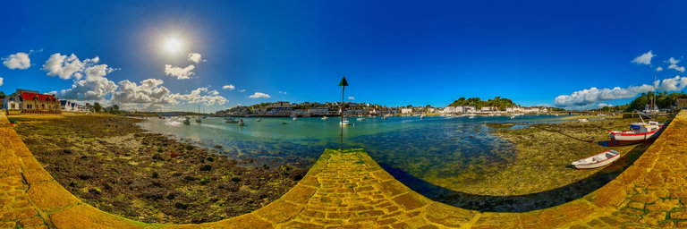
We are in the vertical of the old market square, whose partial facade has remained in remembrance of the old building of the municipal market. aerial view
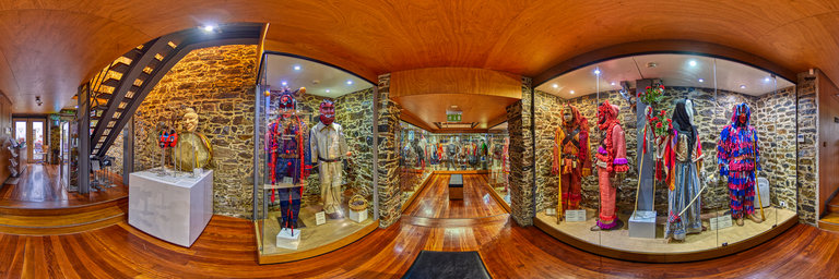
360° panorama by Santiago Ribas - 360portugal. Click the image to open the interactive version.
Mask Museum. Inaugurated in 2007, it is a space for the dissemination of traditions related to the masks of the Northeast Transmontano and the Zamora Region (partnership between the Municipality of Braganca and the Diputaci'on de Zamora - Masks Project). Unique place where masks, costumes, props and objects made by Portuguese and Spanish artisans and used in the “Winter Festivals” in Tr'as-os-Montes and Alto Douro and Zamora are on display.
360° panorama by Santiago Ribas - 360portugal. Click the image to open the interactive version.
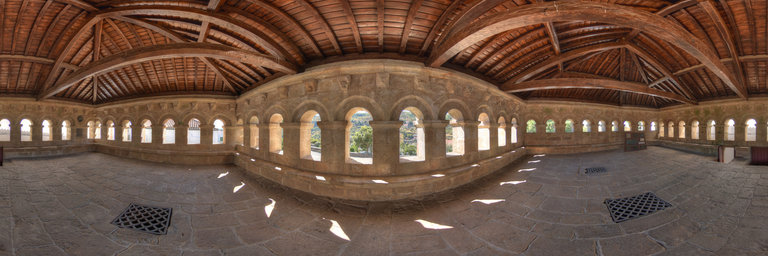
Without documentary evidence, the building can date back to the early days of the borough (nothing of its original design was detected). In the middle of the 13th century, we know this from the Aphonsine inquiries - the parish of Sta. Maria, most likely based in the church of the same name, was among the four in the cluster. The most significant changes occurred during the 16th, 17th and 18th centuries: Erected in the third quarter of five hundred, the body of the monument has an interior divided into three naves by polygonal columns (built in brick) that support half-point arches, modeling the space of this church-hall; the chancel (must date from 1580) and the chapel of Figueiredos (dedicated to N. Sra. dos Prazeres) was ordered to be executed in 1585 by Pero de Figueiredo (mayor of Braganca); of the century. XVII, the altarpiece dedicated to Sto. Estev~ao and the precious and expressive image of Sta. Maria Madalena (main altar), a 17th century work by master Greg'orio Fernandez or Pedro de Mena, from the Valladolid workshops; of the century. XVIII come many decorative elements and some architectural additions, such as the baroque altarpiece of the chancel and the ceiling of the central nave, which presents a painting with scenography with a beautiful effect, in a language that is close to that expressed in the churches of S. Clara, S. Bento, S. Francisco (chapel of N. Sra. Da Conceic~ao) and in the chapel of the old Paco Episcopal (today the Abade de Bacal Museum); the "retable type" facade is animated by a baroque-style portal (1690-1715), in which the pseudo-Solomonic columns and the windings of the pediments play an important role. By the hand of the beds, the carving of the altars materialized in stone, to solemnize the entrance of the holy space.
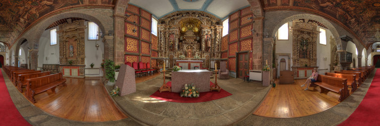
360° panorama by Santiago Ribas - 360portugal. Click the image to open the interactive version.
Without documentary evidence, the building can date back to the early days of the borough (nothing of its original design was detected). In the middle of the 13th century, we know this from the Aphonsine inquiries - the parish of Sta. Maria, most likely based in the church of the same name, was among the four in the cluster. The most significant changes occurred during the 16th, 17th and 18th centuries: Erected in the third quarter of five hundred, the body of the monument has an interior divided into three naves by polygonal columns (built in brick) that support half-point arches, modeling the space of this church-hall; the chancel (must date from 1580) and the chapel of Figueiredos (dedicated to N. Sra. dos Prazeres) was ordered to be executed in 1585 by Pero de Figueiredo (mayor of Braganca); of the century. XVII, the altarpiece dedicated to Sto. Estev~ao and the precious and expressive image of Sta. Maria Madalena (main altar), a 17th century work by master Greg'orio Fernandez or Pedro de Mena, from the Valladolid workshops; of the century. XVIII come many decorative elements and some architectural additions, such as the baroque altarpiece of the chancel and the ceiling of the central nave, which presents a painting with scenography with a beautiful effect, in a language that is close to that expressed in the churches of S. Clara, S. Bento, S. Francisco (chapel of N. Sra. Da Conceic~ao) and in the chapel of the old Paco Episcopal (today the Abade de Bacal Museum); the "retable type" facade is animated by a baroque-style portal (1690-1715), in which the pseudo-Solomonic columns and the windings of the pediments play an important role. By the hand of the beds, the carving of the altars materialized in stone, to solemnize the entrance of the holy space.
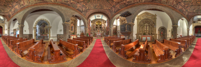
360° panorama by Santiago Ribas - 360portugal. Click the image to open the interactive version.
Without documentary evidence, the building can date back to the early days of the borough (nothing of its original design was detected). In the middle of the 13th century, we know this from the Aphonsine inquiries - the parish of Sta. Maria, most likely based in the church of the same name, was among the four in the cluster. The most significant changes occurred during the 16th, 17th and 18th centuries: Erected in the third quarter of five hundred, the body of the monument has an interior divided into three naves by polygonal columns (built in brick) that support half-point arches, modeling the space of this church-hall; the chancel (must date from 1580) and the chapel of Figueiredos (dedicated to N. Sra. dos Prazeres) was ordered to be executed in 1585 by Pero de Figueiredo (mayor of Braganca); of the century. XVII, the altarpiece dedicated to Sto. Estev~ao and the precious and expressive image of Sta. Maria Madalena (main altar), a 17th century work by master Greg'orio Fernandez or Pedro de Mena, from the Valladolid workshops; of the century. XVIII come many decorative elements and some architectural additions, such as the baroque altarpiece of the chancel and the ceiling of the central nave, which presents a painting with scenography with a beautiful effect, in a language that is close to that expressed in the churches of S. Clara, S. Bento, S. Francisco (chapel of N. Sra. Da Conceic~ao) and in the chapel of the old Paco Episcopal (today the Abade de Bacal Museum); the "retable type" facade is animated by a baroque-style portal (1690-1715), in which the pseudo-Solomonic columns and the windings of the pediments play an important role. By the hand of the beds, the carving of the altars materialized in stone, to solemnize the entrance of the holy space.
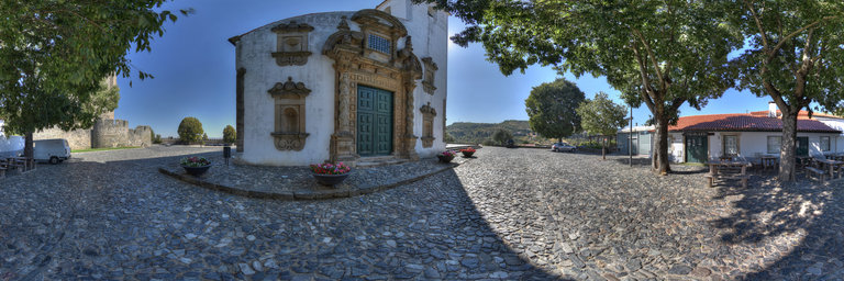
360° panorama by Santiago Ribas - 360portugal. Click the image to open the interactive version.
Although much has been written about its purpose, there is no consensus among scholars. It served as a water cistern, but there are doubts as to whether this was its original function. The name because it is known today (in Latin "Domus Municipalis", in Portuguese "Casa Municipal") is due to the fact that it was used as a City Hall by the Municipal Administration of Braganca. In stone masonry, it presents a plan in the form of an irregular pentagon. It has an underground, which houses a vaulted cistern.
360° panorama by Santiago Ribas - 360portugal. Click the image to open the interactive version.
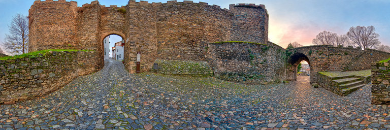
The main door of Santo Ant'onio, in a perfect round arch, between two turrets, is defended by a barbican, in which the Porta da Vila is located, in a pointed arch. Inside, in the Plaza de Armas, it is possible to observe the adaptations of the accesses and the platforms intended for artillery. It has two doors, in a perfect round arch, between prismatic cubes, interconnected by the structuring way of the city, the main door being flanked by two prismatic cubes and reinforced by barbican, both represented in the drawings of Duarte de Armas. The fence also integrates the SO. a breastplate to protect a source of water supply, the king's well, and, almost to the O., a tall tower with outer faces with a semicircular section in the center.
360° panorama by Ackermann Ralf. Click the image to open the interactive version.
Eibelstadt is the smallest town in the Free State of Bavaria in terms of area. The city is locatedon the right bank of the river Main between the cities of W"urzburg and Ochsenfurt. In the middle of the Old Town, near the Market Square, the Catholic parish church of St. Nicholas enthroned with its distinctive tower over the adjacent half-timbered houses.