Добавить любой RSS - источник (включая журнал LiveJournal) в свою ленту друзей вы можете на странице синдикации.
Исходная информация - http://www.360cities.net/. Данный дневник сформирован из открытого RSS-источника по адресу http://www.360cities.net/rss/rss.xml, и дополняется в соответствии с дополнением данного источника. Он может не соответствовать содержимому оригинальной страницы. Трансляция создана автоматически по запросу читателей этой RSS ленты. По всем вопросам о работе данного сервиса обращаться со страницы контактной информации.[Обновить трансляцию]
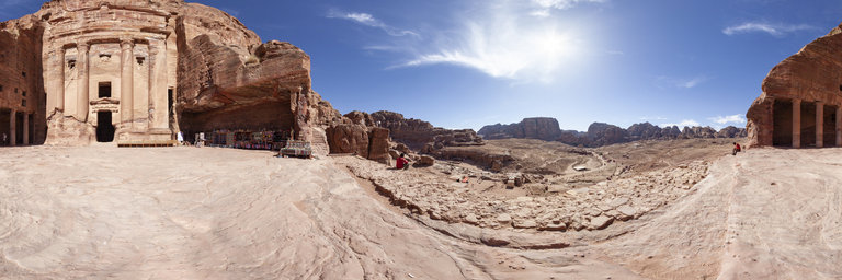
360° panorama by Luis Davilla. Click the image to open the interactive version.
Jordan, Petra: the Monastery / Ad Deir and its cliff - donkeys outside - UNESCO world heritage site
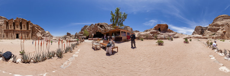
360° panorama by Luis Davilla. Click the image to open the interactive version.
Jordan, Petra: the Monastery / Ad Deir and its cliff - donkeys outside - UNESCO world heritage site
360° panorama by Andrew Bodrov. Click the image to open the interactive version.
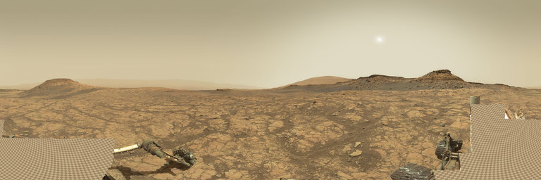
NASA's Mars Exploration Program (Image credit: NASA/JPL-Caltech/MSSS) Sol 2750: Preparing to Drill 'Glasgow' The images for panorama obtained by the rover's 34-millimeter Mast Camera. The mosaic, which stretches about 30,000 pixels width, includes 133 images taken on Sol 2711 (May 1, 2020). Today the MSL team planned initial activities at the next planned drill site, "Glasgow." The plan for today is to gather science data about the site before drilling. This is very similar to what a field geologist on Earth would do. Before gathering a sample, geologists must first: 1. Determine what rock they want to sample, 2. Find the best location for sample collection, and 3. Record all relevant field observations/data in a standard field notebook. Despite the closest human geologist being over 186 million kilometers (115 million miles) away, our curious little robotic geologist has all the tools necessary to do a similar assessment on Mars (with a little help from some humans on Earth). In the case of Curiosity's current drill campaign, we had already determined which rock type we wanted to sample for this drill campaign and identified and drove to the location where the best sample could be obtained. Now, since JPL decided to not send a good ol' fashioned pencil and field notebook to Mars (tsk! tsk!), we'll instead store our data in the onboard computer and then transmit it to Earth. That way those ever curious human geologists can "get their hands dirty" analyzing what will be a LOT of new data about our drill site! So today ChemCam, APXS, and Mastcam are measuring the composition of the drill target Glasgow, and MAHLI is taking images of this target before and after removing dust in order to document the rock surface prior to drilling. ChemCam will also target "Dalmellington Burns," "George Square," and "Large Island" for additional geochemical context of the drill area while Mastcam documents each of these targets with beautiful images. APXS will also look to the sky to measure atmospheric chemistry. Additionally, Mastcam will take a 360° mosaic, REMS, DAN, and RAD will provide remote sensing measurements of the atmospheric and subsurface environment, and Navcam will search for atmospheric dust, clouds and dust devils. That should be enough data to satisfy any geologist! Written by Sean Czarnecki Planetary Geologist at Arizona State University Other panoramas of Mars by Curiosity rover: http://www.360cities.net/sets/curiosity-mars
360° panorama by Gary Davies. Click the image to open the interactive version.
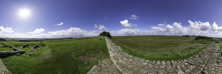
Stretching 73 miles from coast to coast, Hadrian’s Wall was built to guard the wild north-west frontier of the Roman Empire. Housesteads, known as Vercovicium to the 1,000 soldiers garrisoned there, is the best preserved Roman fort in Britain. Standing on a hilltop alongside Hadrian's Wall, it was built in the 2nd century AD and used by the Romans for 300 years. During the late 17th century it was utilised as a stockade for stolen livestock by a family of notorious Border Reivers.
360° panorama by Gary Davies. Click the image to open the interactive version.
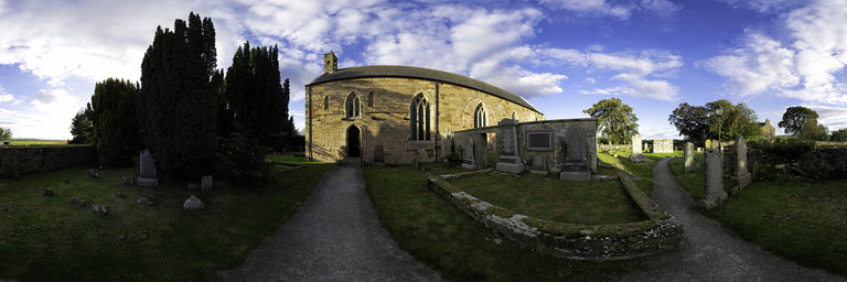
Fearn Abbey is the most northerly monastic foundation in Scotland. Built in 1238, it housed a Premonstratensian order, also known as White Canons because due to their unbleached wool habits. The post-Reformation church that survives today largely dates from reconstruction in 1772. It was rebuilt after being destroyed by lightning in 1742, when the stone-flagged roof collapsed onto the congregation during a Sunday service.
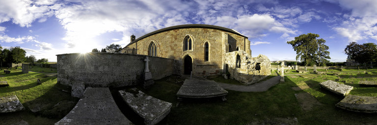
360° panorama by Gary Davies. Click the image to open the interactive version.
Fearn Abbey is the most northerly monastic foundation in Scotland. Built in 1238, it housed a Premonstratensian order, also known as White Canons because due to their unbleached wool habits. The post-Reformation church that survives today largely dates from reconstruction in 1772. It was rebuilt after being destroyed by lightning in 1742, when the stone-flagged roof collapsed onto the congregation during a Sunday service.