Добавить любой RSS - источник (включая журнал LiveJournal) в свою ленту друзей вы можете на странице синдикации.
Исходная информация - http://www.360cities.net/. Данный дневник сформирован из открытого RSS-источника по адресу http://www.360cities.net/rss/rss.xml, и дополняется в соответствии с дополнением данного источника. Он может не соответствовать содержимому оригинальной страницы. Трансляция создана автоматически по запросу читателей этой RSS ленты. По всем вопросам о работе данного сервиса обращаться со страницы контактной информации.[Обновить трансляцию]
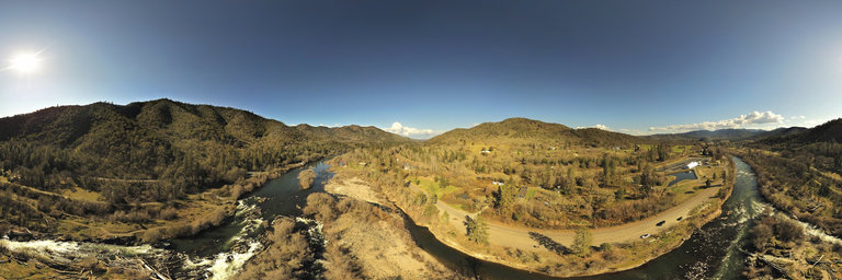
360° panorama by William l. Click the image to open the interactive version.
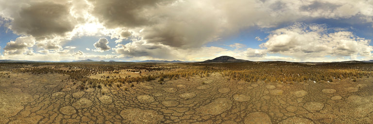
I spotted these strange patterns on Google satellite imagery & had to see what they were in person. From ground level they don't stand out but flying 150 in the air they are quite fascinating. They are located in a remote area east of Mt. Hebron, California & consist of a barren meadow slightly higher than the surrounding juniper plains. The lava rock lines are void of plants & seem to have a manmade patterning even from ground level, however I suspect they are natural in formation, almost periglacial except this is drier desert country. The entire meadow is the same elevation though the larger circles consist of slightly higher gradual mounds a few feet high. They remind me of fairy circles & the fact that the area is void of trees may in fact be of some underground fungi existing underground. The patternings end at the edge of the junipers. I also thought maybe the rock lines are underground streams but the water table wouldn't be as high as in the forests. There are a few other meadows with these exact formations trending northeast.
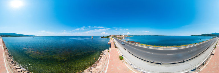
360° panorama by Simona Bartolomei. Click the image to open the interactive version.
Orbetello is located in the middle of the lagoon and is connected to Monte Argentario by a road built on an artificial dam that divides the sea into Laguna di Levante and Laguna di Ponente. This 360 ° panoramic image was taken along this road. The Spanish mill stands in the water.
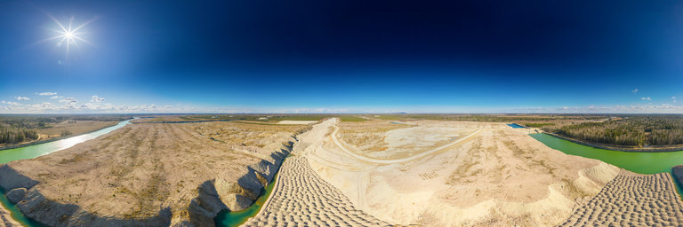
360° panorama by Andrew Bodrov. Click the image to open the interactive version.
Aidu quarry is an open pit mine in Ida-Viru County which opened in 1974. Villages in Aidu were inhabited before the establishment of the oil shale mine, with the earliest records of human habitation in the Aidu area dating back as far as 1241. The villages of Aidu, Aidu-N~omme and Aidu-Liiva disappeared during the establishment of the quarry and over 200 families were forced to leave their homes. The dig site area of the quarry was around 25 km2 and its oil shale output reached up to about 2.4 million tons a year. About 90 million tons of oil shale was mined from the quarry. Mining operations in Aidu ended in 2012 due to the exhaustion of its natural resources. Eesti Energia Kaevandused AS carried out the tidying-up operations in the mine to close the quarry and make it safe. The ground was made level, trees were planted and a rowing channel was established in the course of these operations. When the quarry was closed and pumping stopped, the exit roads at the south end of the quarry filled with water and a unique artificial water body or side channel system was created. The oldest parts of the quarry have been restored as farm and forest land. Source: Aidu Watersports Centre
360° panorama by Flaviopsv. Click the image to open the interactive version.
The Bibi Khanym mausoleum is a Samarkand mausoleum in Uzbekistan. It dates back to the 14th century and was restored in 2007. Inside are the tombs of Bibi Khanum and other family members.https://it.wikipedia.org/wiki/Mausoleo_di_Bibi-Khanymphoto: Zeiss Loxia 21mmoriginal size 28000x14000www.abagontheroad.com
360° panorama by Flaviopsv. Click the image to open the interactive version.
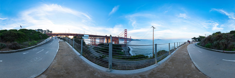
The Golden Gate Bridge is a suspension bridge spanning the Golden Gate, the one-mile-wide (1.6 km) strait connecting San Francisco Bay and the Pacific Ocean. The structure links the American city of San Francisco, California—the northern tip of the San Francisco Peninsula—to Marin County, carrying both U.S. Route 101 and California State Route 1 across the strait. The bridge is one of the most internationally recognized symbols of San Francisco, California, and the United States. It has been declared one of the Wonders of the Modern World by the American Society of Civil Engineers.https://en.wikipedia.org/wiki/Golden_Gate_BridgeThe San Francisco cable car system is the world's last manually operated cable car system. An icon of San Francisco, the cable car system forms part of the intermodal urban transport network operated by the San Francisco Municipal Railway. Of the 23 lines established between 1873 and 1890, only three remain (one of which combines parts of two earlier lines): two routes from downtown near Union Square to Fisherman's Wharf, and a third route along California Street. While the cable cars are used to a certain extent by commuters, the vast majority of their 7 million annual passengers are tourists, and as a result, the wait to get on can often reach two hours or more. They are among the most significant tourist attractions in the city, along with Alcatraz Island, the Golden Gate Bridge, and Fisherman's Wharf. The cable cars are listed on the National Register of Historic Places.The cable cars are separate from San Francisco's heritage streetcars, which operate on Market Street and the Embarcadero, as well as from the more modern Muni Metro light rail system. https://en.wikipedia.org/wiki/San_Francisco_cable_car_systemphoto: Zeiss Loxia 21mmoriginal size 29000x14500www.abagontheroad.com
360° panorama by Flaviopsv. Click the image to open the interactive version.
The Golden Gate Bridge is a suspension bridge spanning the Golden Gate, the one-mile-wide (1.6 km) strait connecting San Francisco Bay and the Pacific Ocean. The structure links the American city of San Francisco, California—the northern tip of the San Francisco Peninsula—to Marin County, carrying both U.S. Route 101 and California State Route 1 across the strait. The bridge is one of the most internationally recognized symbols of San Francisco, California, and the United States. It has been declared one of the Wonders of the Modern World by the American Society of Civil Engineers.https://en.wikipedia.org/wiki/Golden_Gate_BridgeThe San Francisco cable car system is the world's last manually operated cable car system. An icon of San Francisco, the cable car system forms part of the intermodal urban transport network operated by the San Francisco Municipal Railway. Of the 23 lines established between 1873 and 1890, only three remain (one of which combines parts of two earlier lines): two routes from downtown near Union Square to Fisherman's Wharf, and a third route along California Street. While the cable cars are used to a certain extent by commuters, the vast majority of their 7 million annual passengers are tourists, and as a result, the wait to get on can often reach two hours or more. They are among the most significant tourist attractions in the city, along with Alcatraz Island, the Golden Gate Bridge, and Fisherman's Wharf. The cable cars are listed on the National Register of Historic Places.The cable cars are separate from San Francisco's heritage streetcars, which operate on Market Street and the Embarcadero, as well as from the more modern Muni Metro light rail system. https://en.wikipedia.org/wiki/San_Francisco_cable_car_systemphoto: Zeiss Loxia 21mmoriginal size 29000x14500www.abagontheroad.com