Добавить любой RSS - источник (включая журнал LiveJournal) в свою ленту друзей вы можете на странице синдикации.
Исходная информация - http://www.360cities.net/. Данный дневник сформирован из открытого RSS-источника по адресу http://www.360cities.net/rss/rss.xml, и дополняется в соответствии с дополнением данного источника. Он может не соответствовать содержимому оригинальной страницы. Трансляция создана автоматически по запросу читателей этой RSS ленты. По всем вопросам о работе данного сервиса обращаться со страницы контактной информации.[Обновить трансляцию]
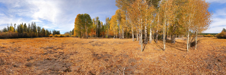
360° panorama by William l. Click the image to open the interactive version.
Several aspen groves align a meadow near Chiloquin, Oregon. The fresh autumn smell combined with the blue sky & sun hitting the white bark of the aspens is one of my favorite contrasts, though this summer was particularly dry, leaving the colors lacking in vibrance.
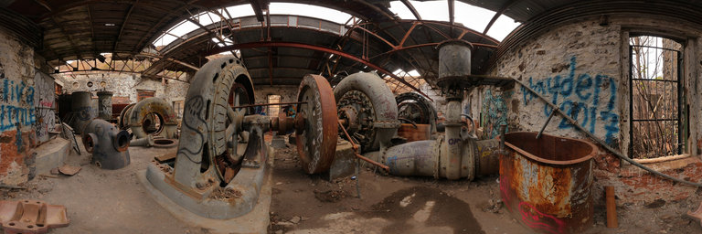
360° panorama by William l. Click the image to open the interactive version.
A view of the abandoned White River Hydroelectric Powerplant at White River Falls State Park near Tygh Valley, Oregon. It is one of the first hydroelectric power plants in operation, having run from 1901 to 1963. It provided power to Sherman & Wasco Counties. Today it sits in long decay with its turbines inside as well as an accumulation of artwork. Also in the vicinity is the ruins of a concrete dam & diversion pool.
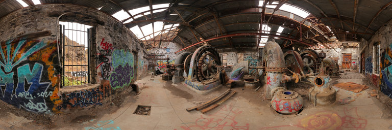
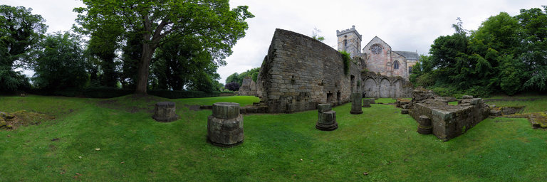
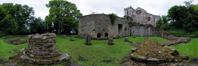
360° panorama by Gary Davies. Click the image to open the interactive version.
Culross Abbey was built for Cistercian monks in the 1200s and survived until the Reformation of 1560. The abbey church became the parish church, which in its current form dates back to around 1632. It is located high on a hillside above the coastal village of Culross. The unusual setting is thought to be the site of an early Christian community led by St Serf and of which St Kentigern (Mungo) was a member. When monastic life came to an end the domestic buildings were left to fall into ruin. Only parts of the nave and cellarium remain, along with the foundations and piers of the undercrofts of the east range and frater.
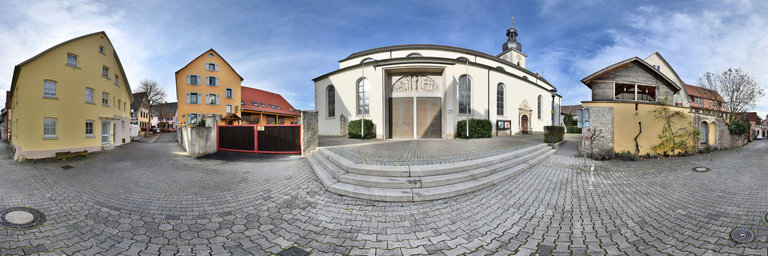
360° panorama by Ackermann Ralf. Click the image to open the interactive version.
The Roman Catholic Church of St. James in Lauda was built from 1322 in the Gothic style. In 1608, with the exception of the old choir, it was completely demolished. The new church was rebuilt as a basilica. On December 28, 1694, the basilica burned down to its foundations. The reconstruction took three years. During World War II, the tower fell after bombardment in the nave. Once again, St. James had to be laboriously repaired.
360° panorama by Gary Davies. Click the image to open the interactive version.
Culross Abbey was built for Cistercian monks in the 1200s and survived until the Reformation of 1560. The abbey church became the parish church, which in its current form dates back to around 1632. It is located high on a hillside above the coastal village of Culross. The unusual setting is thought to be the site of an early Christian community led by St Serf and of which St Kentigern (Mungo) was a member. When monastic life came to an end the domestic buildings were left to fall into ruin. Only parts of the nave and cellarium remain, along with the foundations and piers of the undercrofts of the east range and frater.
360° panorama by Gary Davies. Click the image to open the interactive version.
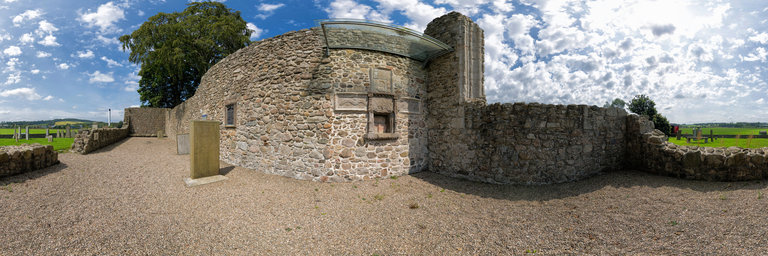
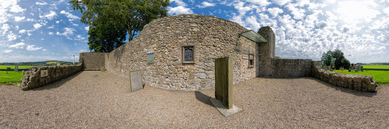
The ruins of this simple, rectangular Highland church dating from the 13th century are located well off the beaten track, near Inverurie, in rural Aberdeenshire. Once associated with the Knights Hospitallers, the church was remodelled for Presbyterian worship following the Protestant Reformation of 1560. Although much of the building was demolished in the late 18th century, to provide building materials for a new parish church, it retains some interesting fixtures. The sacrament house features some now defaced cross-shaped carved stone panels and an adjacent replica brass panel shows the crucifixion and a representation of St Michael the Archangel. There is also a finely carved grave slab of the knight Gilbert de Greenlaw, who was killed at the nearby Battle of Harlaw in 1411. It has survived remarkably intact as it was re-used for another grave in 1592, with the original carving protected from weathering.
360° panorama by Gary Davies. Click the image to open the interactive version.
The ruins of this simple, rectangular Highland church dating from the 13th century are located well off the beaten track, near Inverurie, in rural Aberdeenshire. Once associated with the Knights Hospitallers, the church was remodelled for Presbyterian worship following the Protestant Reformation of 1560. Although much of the building was demolished in the late 18th century, to provide building materials for a new parish church, it retains some interesting fixtures. The sacrament house features some now defaced cross-shaped carved stone panels and an adjacent replica brass panel shows the crucifixion and a representation of St Michael the Archangel. There is also a finely carved grave slab of the knight Gilbert de Greenlaw, who was killed at the nearby Battle of Harlaw in 1411. It has survived remarkably intact as it was re-used for another grave in 1592, with the original carving protected from weathering.
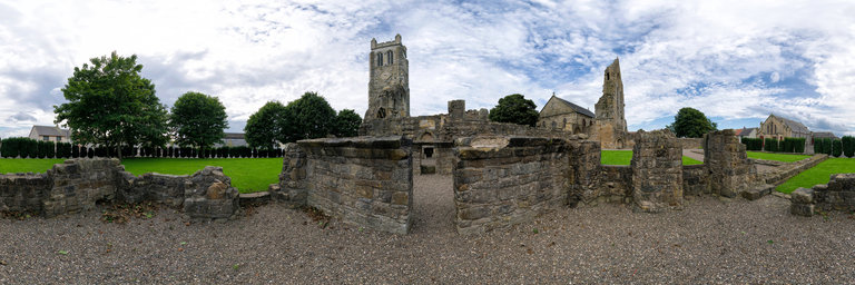
360° panorama by Gary Davies. Click the image to open the interactive version.
Once one of the greatest abbeys in Scotland, the scant ruins of Kilwiinning Abbey are quietly hidden away in a North Ayrshire housing estate. It was founded in the 12th century and populated by Tironesian monks from Kelso Abbey in the Scottish Borders. Despite the turbulent times, the monastery survived largely unscathed for 400 years, until falling into decline after the Protestant Reformation of 1560. The best-preserved parts of the abbey today are the south transept, the south nave wall, including the east processional doorway, and part of the west front. In 1814, the north-west bell tower collapsed. It was replaced by the present clock tower the following year.
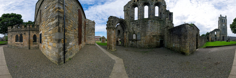
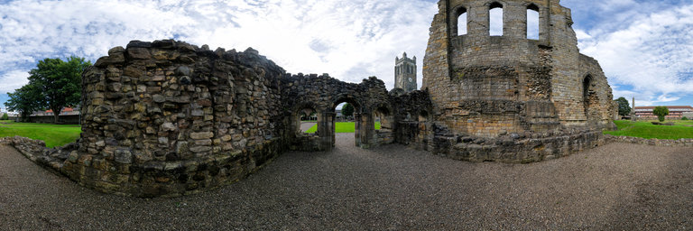
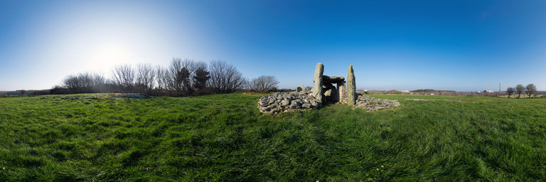
360° panorama by Gary Davies. Click the image to open the interactive version.
The remains of a trio of Neolithic chambered tombs constructed in separate phases between 3750-3500 BC. The standing stones that remain are part of what would have been an earth and turf covered barrow. The two large uprights mark the probable entrance to the original chamber. The radiocarbon dating of artefacts found at the site, such as pottery shards and flints, have been dated to around 3100 BC.