Добавить любой RSS - источник (включая журнал LiveJournal) в свою ленту друзей вы можете на странице синдикации.
Исходная информация - http://www.360cities.net/. Данный дневник сформирован из открытого RSS-источника по адресу http://www.360cities.net/rss/rss.xml, и дополняется в соответствии с дополнением данного источника. Он может не соответствовать содержимому оригинальной страницы. Трансляция создана автоматически по запросу читателей этой RSS ленты. По всем вопросам о работе данного сервиса обращаться со страницы контактной информации.[Обновить трансляцию]
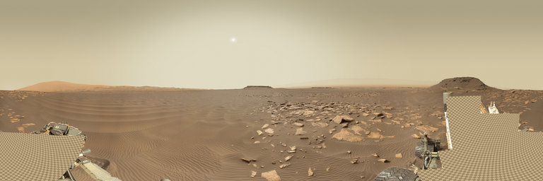
360° panorama by Andrew Bodrov. Click the image to open the interactive version.
NASA's Mars Exploration Program (Image credit: NASA/JPL-Caltech/MSSS) Sol 1601: Celebrating Sol 1600 with “Whiskey” and “Rye” The images for panorama obtained by the rover's 34-millimeter Mast Camera. The mosaic, which stretches about 30,000 pixels width, includes 112 images taken on Sol 1601 (February 5, 2017). Wow, 1600 sols on Mars – that is quite an accomplishment! And we're at an exciting point in the traverse as we approach the next segment of the Bagnold Dunes. Curiosity's weekend plan includes more contact science and driving as we continue to investigate the Murray formation and prepare for observations at the active sand dunes. This Saturday is a soliday (a day without planning to allow Earth and Mars schedules to sync back up), so we'll transition from a late slide sol today to early slide sols next week. The plan begins with additional imaging of "Ireson Hill" to document the bedding geometry and cap rock from a different viewing position. We'll also take a Mastcam tau, a Navcam dust devil movie, and a Mastcam image to monitor the rover deck. Then Curiosity will acquire MAHLI images of two targets: "Whiskey" and "Rye" (hmmm, perhaps some Sol 1600 celebrations are in order), with a short APXS integration on "Whiskey" and a longer overnight integration on "Rye." Both targets were selected to study the stratification and chemistry of the Murray formation here. On Sol 1601, Curiosity will carry out some drill diagnostics, followed by a drive and post-drive imaging. We'll also take a Mastcam 360-degree mosaic, which should be very scenic from this site – looking out over the dunes and capturing features like "Ireson Hill." And finally, Curiosity will wake up early on Sol 1602 for a suite of environmental monitoring observations. Stay tuned for the second investigation of the Bagnold Dunes next week! Lauren Edgar Research Geologist at the USGS Astrogeology Science Center and a member of the MSL science team Other panoramas of Mars by Curiosity rover: http://www.360cities.net/sets/curiosity-mars
360° panorama by William l. Click the image to open the interactive version.
Aerial view overlooking the old Elk Creek Dam ruins along Elk Creek near Trail, Oregon. Construction of the dam started in the 1980s & was halted in 1987 due to a court injunction related to protecting endangered salmon. Dam building ceased & the site was left abandoned until 2008 when part of it was dynamited so Elk Creek could run its natural course. If completed, Elk Creek Lake would've formed behind for several miles upstream with the dam being 240 feet in height.
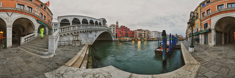
360° panorama by Kent Johnson. Click the image to open the interactive version.
Early morning, daybreak on the Riva del Vin with the local street sweepers tidying the famous Rialto Bridge, Ponte di Rialto, before the daily onslaught of thousands of tourists.
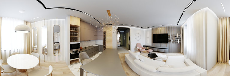
360° panorama by Yves Provence. Click the image to open the interactive version.
Cette carri`ere fut jadis le lieux d'une exploitation de la Pierre de Mane, une pierre ocr'ee utilis'ee pour la construction de nombreux 'edifices. Dans les plus anciennes veines, aujourd’hui envahies par la v'eg'etation, on extrayait des blocs de taille modeste, dans le sens du pendage* des bancs, `a l’aide de pics et d’escoudes. Dans les plus r'ecentes veines on voit la marque de m'ethodes d’extraction modernes qui ne tiennent aucun compte du pendage des bancs. On observe aussi les traces laiss'ees par une haveuse verticale; ailleurs par une haveuse horizontale. Des rails fix'es au toit de la galerie permettaient aux haveuses de d'ecouper de gros blocs (quelques m`etres cubes). Parfois, certains, trop gros et trop lourds se cassaient, obligeant l’exploitant `a les retailler en blocs plus petits. --- This quarry was once the site of exploitation of the Stone of Mane, an ocher stone used for the construction of many buildings. In the oldest veins, now overgrown, small boulders were quarried, dipping the banks, using picks and squares. In the most recent veins we see the mark of modern mining methods which do not take into account the dip of the beds. We can also observe the traces left by a vertical chopper; elsewhere by a horizontal chopper. Rails attached to the roof of the gallery allowed the shearers to cut large blocks (a few cubic meters). Sometimes, some that were too big and too heavy would break, forcing the operator to cut them back into smaller blocks.
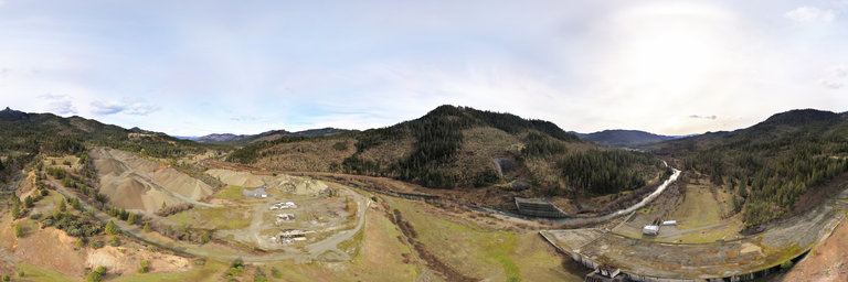
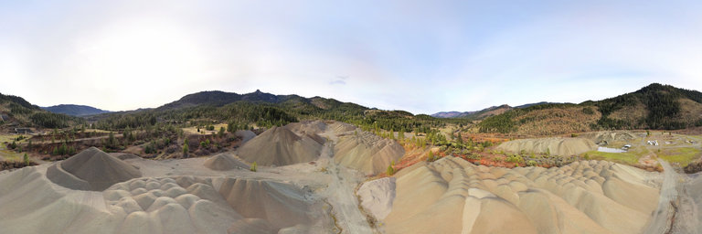
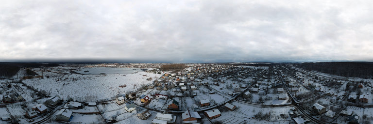
360° panorama by William l. Click the image to open the interactive version.
Aerial view overlooking the old Elk Creek Dam ruins along Elk Creek near Trail, Oregon. Construction of the dam started in the 1980s & was halted in 1987 due to a court injunction related to protecting endangered salmon. Dam building ceased & the site was left abandoned until 2008 when part of it was dynamited so Elk Creek could run its natural course. If completed, Elk Creek Lake would've formed behind for several miles upstream with the dam being 240 feet in height.
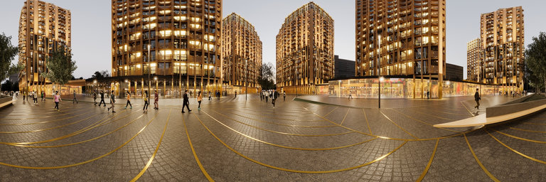
360° panorama by Alain AUZERAL. Click the image to open the interactive version.
Jarnac in the Charente department in southwestern France is situated on the right bank of the river Charente between Angoul^eme and Cognac.
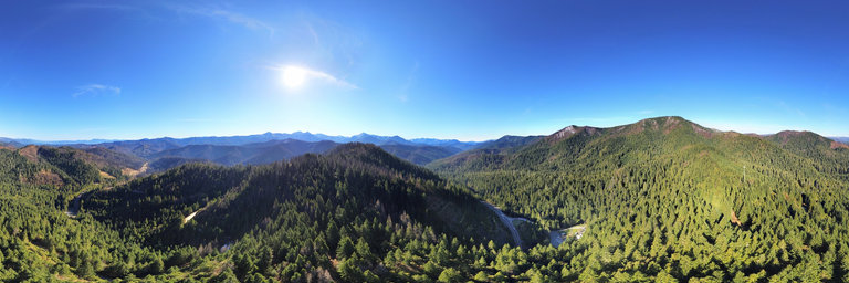
360° panorama by William l. Click the image to open the interactive version.
Aerial view from near Hazel View Summit just south of the California/Oregon state line. This view is near the old Oregon Mountain Road & has views of both sides of Highway 199 as it enters the Randolph Collier Tunnel directly underneath. Good views of the snowy Preston Peak area & its satellite summits.