Добавить любой RSS - источник (включая журнал LiveJournal) в свою ленту друзей вы можете на странице синдикации.
Исходная информация - http://www.360cities.net/. Данный дневник сформирован из открытого RSS-источника по адресу http://www.360cities.net/rss/rss.xml, и дополняется в соответствии с дополнением данного источника. Он может не соответствовать содержимому оригинальной страницы. Трансляция создана автоматически по запросу читателей этой RSS ленты. По всем вопросам о работе данного сервиса обращаться со страницы контактной информации.[Обновить трансляцию]
Понедельник, 26 Октября 2020 г. 18:56
+ в цитатник
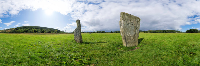
360° panorama by Gary Davies. Click the image to open the interactive version.
Located close to other ancient stone circles and cairns in Kilmartin Glen, the Nether Largie standing stones comprise five tall, decorated standing stones arranged in an 'X' formation. They were erected about 3,200 years ago during the Bronze Age. Their deliberate alignment has led to a theory that they were possibly used as a lunar observatory.
Понедельник, 26 Октября 2020 г. 18:56
+ в цитатник
360° panorama by Gary Davies. Click the image to open the interactive version.
Located close to other ancient stone circles and cairns in Kilmartin Glen, the Nether Largie standing stones comprise five tall, decorated standing stones arranged in an 'X' formation. They were erected about 3,200 years ago during the Bronze Age. Their deliberate alignment has led to a theory that they were possibly used as a lunar observatory.
Понедельник, 26 Октября 2020 г. 18:07
+ в цитатник
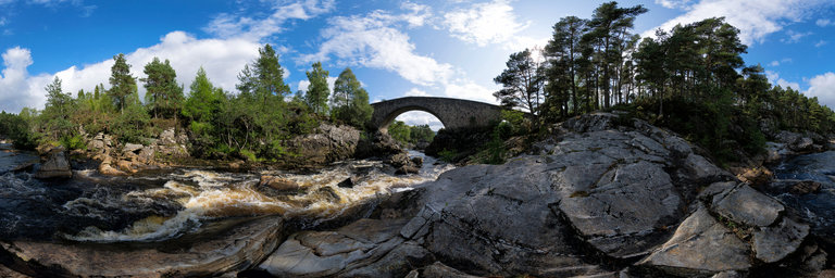
360° panorama by Gary Davies. Click the image to open the interactive version.
The historic stone bridge at Little Garve spans the Black Water river on the old military road between Contin to Poolewe. Built in 1762, it formed part of a wider barracks, bridge and road network built across Scotland following the Jacobite uprising of 1745. Instigated by the English Army's General Wade, the military infrastructure was designed to make it easier for troops to quickly move around the country to quell any further insurrection.
Понедельник, 26 Октября 2020 г. 18:07
+ в цитатник
360° panorama by Gary Davies. Click the image to open the interactive version.
The historic stone bridge at Little Garve spans the Black Water river on the old military road between Contin to Poolewe. Built in 1762, it formed part of a wider barracks, bridge and road network built across Scotland following the Jacobite uprising of 1745. Instigated by the English Army's General Wade, the military infrastructure was designed to make it easier for troops to quickly move around the country to quell any further insurrection.
Понедельник, 26 Октября 2020 г. 18:01
+ в цитатник
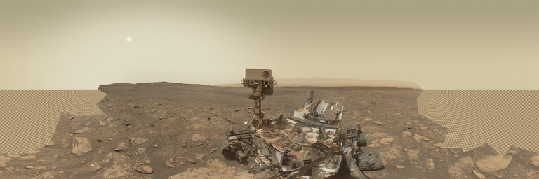
360° panorama by Andrew Bodrov. Click the image to open the interactive version.
NASA's Mars Exploration Program (Image credit: NASA/JPL-Caltech/MSSS) Sol 2922: Penultimate Plan This panorama combines 56 exposures taken by the rover's Mars Hand Lens Imager (MAHLI) during the Sol 2922 of Curiosity's work on Mars (October 24, 2020) We are in the homestretch of our time at the “Mary Anning” and “Groken” drill sites, and today’s plan checks off some of the final important boxes to complete our analyses here before we head back uphill. With sample delivered to SAM, we will clear the remaining sample out of the drill and have a look at the discarded sample with MAHLI and APXS. The chemistry of the Groken drill sample from APXS will be combined with the mineralogy determined by CheMin and the volatile contents determined by SAM to build a comprehensive picture of the origin and history of this part of "Gale Crater." MAHLI will also look at the Groken drill hole tailings, which have been somewhat scattered by the wind since we created them on Sol 2910. We will also look around and beyond the drill target with our remote sensing instruments. ChemCam will acquire chemistry from the target “Vord,” a clean, broken surface exposed during the drill activity. We do not often get such new, dust-free surfaces on Mars so we like to take advantage of clean looks at their chemistry and texture. ChemCam will add to the extensive, spectacular collection of RMI images of the “Housedon Hill” area east of the rover, which reveal a real wonderland of geology within Mount Sharp. Mastcam and Navcam will combine forces to measure the amount of dust in the atmosphere, and look for dust devils and clouds. The steady gazes of DAN, RAD and REMS remain fixed on the skies above us and subsurface below us as the other instruments do their work, continuing to build their records of the environment in Gale crater. Written by Michelle MinittiPlanetary Geologist at Framework Other panoramas of Mars by Curiosity rover: http://www.360cities.net/sets/curiosity-mars
Понедельник, 26 Октября 2020 г. 18:01
+ в цитатник
360° panorama by Andrew Bodrov. Click the image to open the interactive version.
NASA's Mars Exploration Program (Image credit: NASA/JPL-Caltech/MSSS) Sol 2922: Penultimate Plan This panorama combines 56 exposures taken by the rover's Mars Hand Lens Imager (MAHLI) during the Sol 2922 of Curiosity's work on Mars (October 24, 2020) We are in the homestretch of our time at the “Mary Anning” and “Groken” drill sites, and today’s plan checks off some of the final important boxes to complete our analyses here before we head back uphill. With sample delivered to SAM, we will clear the remaining sample out of the drill and have a look at the discarded sample with MAHLI and APXS. The chemistry of the Groken drill sample from APXS will be combined with the mineralogy determined by CheMin and the volatile contents determined by SAM to build a comprehensive picture of the origin and history of this part of "Gale Crater." MAHLI will also look at the Groken drill hole tailings, which have been somewhat scattered by the wind since we created them on Sol 2910. We will also look around and beyond the drill target with our remote sensing instruments. ChemCam will acquire chemistry from the target “Vord,” a clean, broken surface exposed during the drill activity. We do not often get such new, dust-free surfaces on Mars so we like to take advantage of clean looks at their chemistry and texture. ChemCam will add to the extensive, spectacular collection of RMI images of the “Housedon Hill” area east of the rover, which reveal a real wonderland of geology within Mount Sharp. Mastcam and Navcam will combine forces to measure the amount of dust in the atmosphere, and look for dust devils and clouds. The steady gazes of DAN, RAD and REMS remain fixed on the skies above us and subsurface below us as the other instruments do their work, continuing to build their records of the environment in Gale crater. Written by Michelle MinittiPlanetary Geologist at Framework Other panoramas of Mars by Curiosity rover: http://www.360cities.net/sets/curiosity-mars
Понедельник, 26 Октября 2020 г. 17:43
+ в цитатник
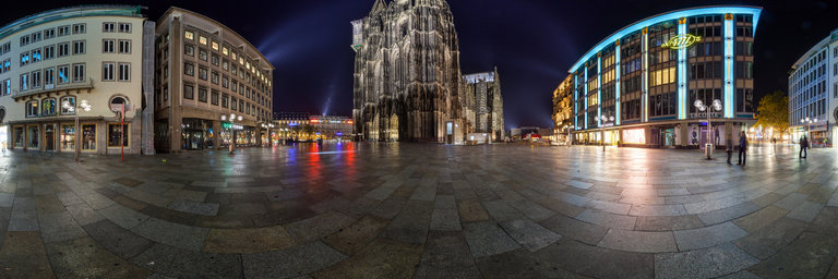
360° panorama by Andrew Bodrov. Click the image to open the interactive version.
Cologne High Cathedral of Saint Peter is a Roman Catholic cathedral in Cologne, Germany. It was declared a UNESCO World Heritage Site in 1996. It is Germany's most visited landmark, attracting an average of 20,000 people a day and currently the tallest twin-spired church at 157 m (515 ft) tall.Source: Wikipedia
Понедельник, 26 Октября 2020 г. 17:43
+ в цитатник
360° panorama by Andrew Bodrov. Click the image to open the interactive version.
Cologne High Cathedral of Saint Peter is a Roman Catholic cathedral in Cologne, Germany. It was declared a UNESCO World Heritage Site in 1996. It is Germany's most visited landmark, attracting an average of 20,000 people a day and currently the tallest twin-spired church at 157 m (515 ft) tall.Source: Wikipedia
Понедельник, 26 Октября 2020 г. 17:38
+ в цитатник
360° panorama by Gary Davies. Click the image to open the interactive version.
Old Castle Lachlan is a remote ruin on the picturesque shores of Loch Fyne. The ruins date back to the 15th century, replacing an earlier fortification on the same rock promontory. It was built by the clan Maclachlan, one of the oldest Scottish Highland clans and staunch Jacobites. Following the death of the 17th clan chief at the Battle of Culloden in 1746, the castle was bombarded by government ships and left uninhabitable.
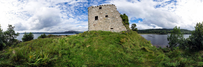
Понедельник, 26 Октября 2020 г. 17:36
+ в цитатник
360° panorama by Gary Davies. Click the image to open the interactive version.
Old Castle Lachlan is a remote ruin on the picturesque shores of Loch Fyne. The ruins date back to the 15th century, replacing an earlier fortification on the same rock promontory. It was built by the clan Maclachlan, one of the oldest Scottish Highland clans and staunch Jacobites. Following the death of the 17th clan chief at the Battle of Culloden in 1746, the castle was bombarded by government ships and left uninhabitable.
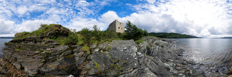
Понедельник, 26 Октября 2020 г. 17:36
+ в цитатник
360° panorama by Gary Davies. Click the image to open the interactive version.
Old Castle Lachlan is a remote ruin on the picturesque shores of Loch Fyne. The ruins date back to the 15th century, replacing an earlier fortification on the same rock promontory. It was built by the clan Maclachlan, one of the oldest Scottish Highland clans and staunch Jacobites. Following the death of the 17th clan chief at the Battle of Culloden in 1746, the castle was bombarded by government ships and left uninhabitable.
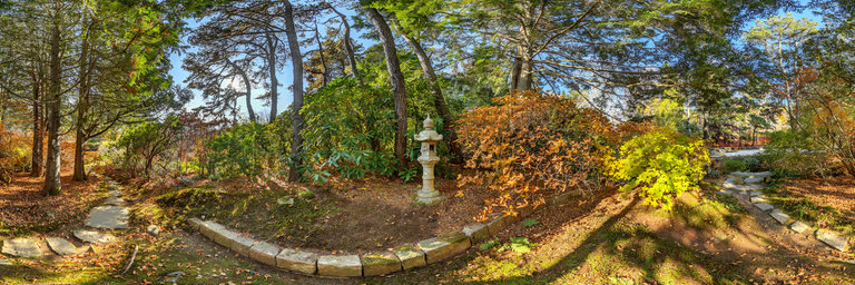
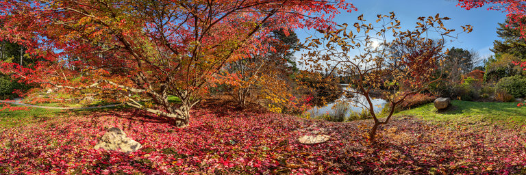
Понедельник, 26 Октября 2020 г. 03:51
+ в цитатник
360° panorama by Udo Lenkewicz. Click the image to open the interactive version.
Beside the old bridge I found this place searching for a quite corner to piss that was worth to capture it. Yellow leaves on he tree are waiting for the next storm to be blown away.