Добавить любой RSS - источник (включая журнал LiveJournal) в свою ленту друзей вы можете на странице синдикации.
Исходная информация - http://www.360cities.net/. Данный дневник сформирован из открытого RSS-источника по адресу http://www.360cities.net/rss/rss.xml, и дополняется в соответствии с дополнением данного источника. Он может не соответствовать содержимому оригинальной страницы. Трансляция создана автоматически по запросу читателей этой RSS ленты. По всем вопросам о работе данного сервиса обращаться со страницы контактной информации.[Обновить трансляцию]
360° panorama by William l. Click the image to open the interactive version.
A 200' aerial view over Methow, Washington, an unincorporated community with a population of 262 in 2000. It was founded in 1889 by W.A. Bolinger & is named after the Methow people who lived in the area before white settlers. Methow itself means 'sunflower seeds'. More info here: https://en.wikipedia.org/wiki/Methow,_Washington
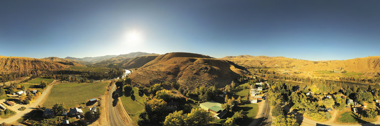
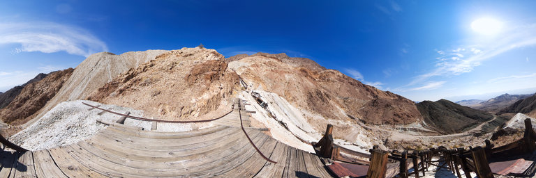
360° panorama by Tim France. Click the image to open the interactive version.
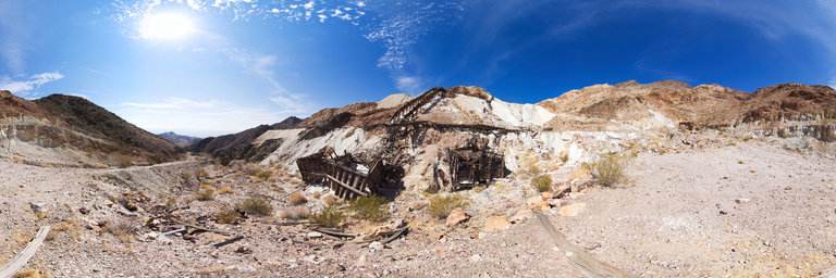
A large talc mine located in southern Death Valley that was discovered in the early-1930s and operated until late-1960s. This is the very top of this large ore chute. The view into the valley below is breath taking.
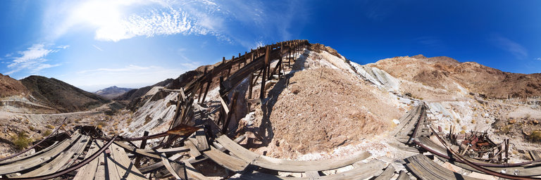
360° panorama by Tim France. Click the image to open the interactive version.
A large talc mine located in southern Death Valley that was discovered in the early-1930s and operated until late-1960s. This is the section above the ore bins and at the bottom of a very large ore chute.
360° panorama by Santiago Ribas - 360portugal. Click the image to open the interactive version.
The intention of the Flavian architect who translated the imperial order and of the city's notables was to build a sacred enclosure that framed the temple dedicated to the worship of the deified emperors and their family.
360° panorama by Santiago Ribas - 360portugal. Click the image to open the interactive version.
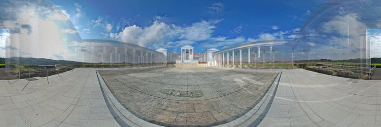
This is the 3D model based on the rigorous reconstruction drawings by Jean-Claude Golvin from the Flavian forum in Conimbriga, provided to me by the Museum of Conimbriga. The model was synchronized with the 360o panoramic photograph of the current reality, showing both situations transparently.
360° panorama by Tim France. Click the image to open the interactive version.
A large talc mine located in southern Death Valley that was discovered in the early-1930s and operated until late-1960s.
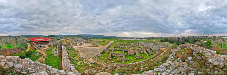
360° panorama by Santiago Ribas - 360portugal. Click the image to open the interactive version.
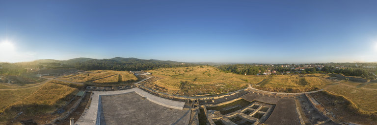
The forum of the Roman city of Conimbriga was located during the archaeological excavations that took place between 1964 and 1971, excavations carried out by a Portuguese-French team that involved the Monographic Museum of Conimbriga, the Archeology Institute of the Faculty of Arts of the University of Coimbra and the University of Bordeaux. The excavations identified the structures of a large monument from Flavian times and, under these, the remains of buildings belonging to an earlier phase that, coinciding in the location of some elements (such as the central square), nevertheless formed a completely different architectural program. . The survival of the forum's structures has, over time, been affected by severe problems: firstly, the abandonment to which the pagan Roman constructions were voted with the advent of Christianity; the ruin of the forum led, some centuries later, to the use of the site as a cemetery, which contributed to the degradation of the remains already partially buried; finally, after the severe destruction already caused by agricultural labors, the forum seems to have been a privileged location for the collection of construction material for modern and contemporary homes, a phenomenon intensified following the fire of neighboring Condeixa-a-Nova by the troops of the French general Massena (1805). What we know today from the Conimbriga forum is, therefore, the result of a careful analysis of what was recovered from the building plan, the remains, in many cases sparse, its constructive and decorative apparatus, and important studies and refunds of what would be its original aspect, fruit of the theoretical reconstruction of the architectural module employed and of the comparison with other similar monuments, spread over the orb of the old Roman Empire. The Conimbriga forum is located in the center of what was the urban space of the city, which also corresponds to a slightly higher area in the day that the city has occupied since its origin. The location of the Flavian forum was conditioned by the pre-existence of the forum built over the first half of the sec. I, which also occupied a central zone from the point of view of the circulation axes of the oppidum. The Flavian forum was designed as a rectangular block bounded by a single wall without openings, except for the monumental entrance; bounded by four streets, its presence was undoubtedly a very strong landmark in the urban structure of the city. Through the streets surrounding the forumpass all the significant axes of the city, from its entrances to the residential areas, the circulation between the main monuments (in addition to the forum, the Amphitheater and the great Baths) was also done there. This situation led to the creation of small squares around it, where public fountains, latrines, etc. were found.
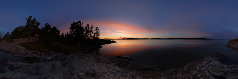
360° panorama by Martin Broomfield. Click the image to open the interactive version.
Eyrie Isle Situated in the middle of the White Fish River First Nation on McGregor Bay, at the northern end of Lake Huron, East of Manitoulin Island. The island can only be accessed by boat and is isolated from the outside world. Clear, cold mornings create beautiful sun rises.
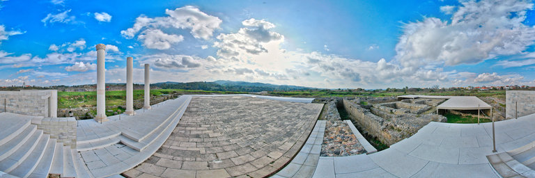
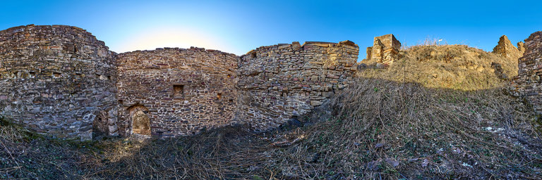
360° panorama by Santiago Ribas - 360portugal. Click the image to open the interactive version.
The wall, apparently made in haste, without the rigor of Roman public works and was built using materials from other constructions, such as the amphitheater. The aspect of these defenses reinforces the idea of a wall erected in a hurry to protect cities from barbarians, in the century. IV.
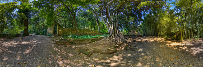
360° panorama by Santiago Ribas - 360portugal. Click the image to open the interactive version.
Green recreational space. Romantic garden. We highlight the rarity and size of some botanical specimens. Strong historical and scenic value, testimony to the taste for botanical collecting that occurred in Portugal from the beginning of the 19th century. The Arauc'arias and Palmeiras collections stand out, as well as the rare examples of Podocarpus, Figueiras, Pl'atanos and Sequ'oias.A place that pays homage to love, the Fonte dos Amores, at Quinta das L'agrimas, is protected by an imposing Australian fig tree (ficus macrophylla), undoubtedly one of the largest specimens of this species in the country.
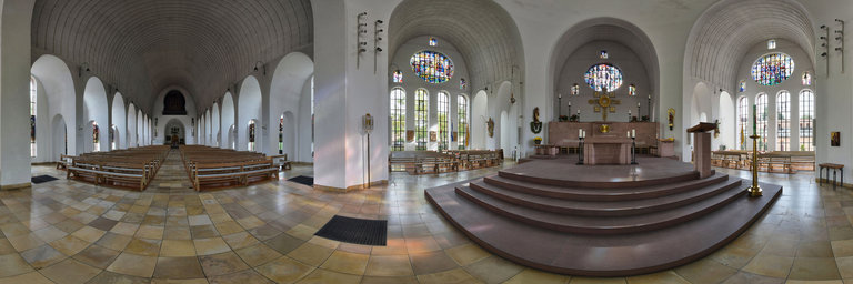
360° panorama by Ackermann Ralf. Click the image to open the interactive version.
The floor plan of St. Laurentius in Kleinostheim forms a cross. At the center of this cross is the chancel, which was redesigned during the major interior renovation in 1978 in accordance with the Second Vatican Council. The chancel is bordered by a high sandstone wall, in the middle of which is the tabernacle with the holy of holies. The goldsmith's work comes from Rudolf Engert.
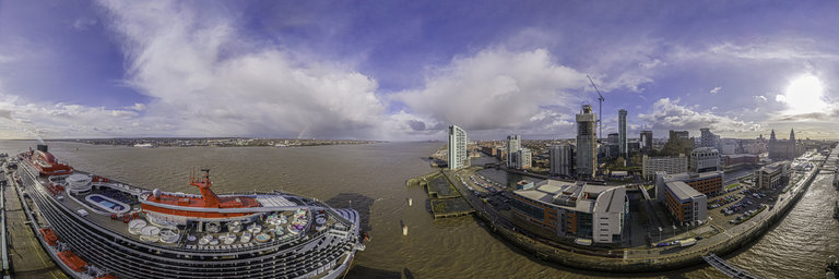
360° panorama by Chris Fenton. Click the image to open the interactive version.
Taken in February 2020 on the Scarlett Lady's maiden visit to Liverpool. The cruise ship has never taken paying passenger yet due to the pandemic.
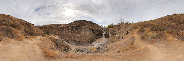
360° panorama by William l. Click the image to open the interactive version.
White River Falls is a state park located near Tygh Valley, Oregon. The top waterfall is named as White River Falls & drops 90 feet while the lower falls drops 44 feet & is named Celestial Falls. The White River originates from the White River Glacier on Mount Hood & is responsible for the muddy murky color of the water from glacial rock flour. An abandoned hydropower plant that ran from 1910 to 1960 is also a highlight of the park located at the bottom of a steep trail.
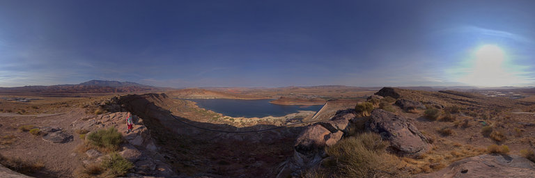
360° panorama by Jon Jasper. Click the image to open the interactive version.
Tate Jasper admiring the view from the Harrisburg Bench Aviation Arrow (Quail Creek Reservoir West Overlook - Beacon 37C). These aviation arrows guided pilots around the west starting in the 1924.
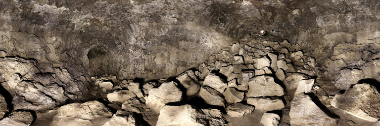
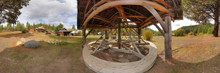
360° panorama by William l. Click the image to open the interactive version.
Standing just inside from the crawl hole entrance to Dynamited Cave near Trout Lake, Washington From here there is a pit w/ a lower (formerly gated) tunnel & an upper passage above that ends mostly in breakdown. I only explored about 400 feet of the cave until I arrived at the first 15' vertical pit. From Oregon Grotto: One of the longest caves in the Trout Lake area with many vertical drops and levels. 12,345 feet. Dynamited Cave was discovered in Spring, 1958, by Reno and Carl Ziegler, loggers with the Broughton Lumber Co. In Oct., 1958, early exploration began when Carl Nielsen, family members and friends entered the cave as far as the 15-ft drop. Sometime between Oct. 18 and Dec. 6, 1958, the most decisive event in this cave's history occurred when--after five local boys were unable to ascend a 40-ft pit they had dropped on a 3/8-inch rope--the entrance was dynamited, ending exploration of the cave until 1961. Dynamite was employed again in late 1972 to destroy one of a series of typically impotent gates, this one some distance inside the cave. This widely popular cave is the most mapped cave in the Trout Lake area. Only moderately sinuous in plan view, it is highly complex in profile, having widely varying multiple levels and abrupt drops. At least ten drops exist within the cave, 6 in the lower sections, and 4 in the attic passage. No other major cave has been found upslope from Dynamited Cave, but the upslope collapse suggests that it should continue beyond due to its size at the point of collapse seal. https://www.oregongrotto.com/troutlake.shtml
360° panorama by William l. Click the image to open the interactive version.
Liberty, Washington is a small unincorporated mining town in 1873, known as the oldest living ghost town in the state. Crystalline gold was found in nearby Swauk Creek, leading to the towns formation, known initially as Williams Creek until 1892. Seen here is a replica arrastra, an ore-pulverizing device that was used during the mining process.
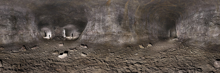
360° panorama by William l. Click the image to open the interactive version.
Cheese Cave is a lava tube located outside of Trout Lake, Washington. It is approximately 2,060' feet in length with very high ceilings, easy walking, & original features. The cave has two natural openings, the south entrance which is accessible via a ladder & a north stairwell entrance to which a private a-frame structure sits directly on top. The cave was discovered by Joseph Arnie in 1894 & was used by Homer Spence, who founded the Guler Cheese Company for storing & aging Roquefort cheese due to its constant 42*F temperature. The operations went from 1930s to 1950s. This view is b/w both entrances showing a three-way split (the two passages with my silhouettes is actually going around a large pillar & connecting further ahead). High ceilings & excellent floor w/ minimal breakdown collapse.