Добавить любой RSS - источник (включая журнал LiveJournal) в свою ленту друзей вы можете на странице синдикации.
Исходная информация - http://www.360cities.net/. Данный дневник сформирован из открытого RSS-источника по адресу http://www.360cities.net/rss/rss.xml, и дополняется в соответствии с дополнением данного источника. Он может не соответствовать содержимому оригинальной страницы. Трансляция создана автоматически по запросу читателей этой RSS ленты. По всем вопросам о работе данного сервиса обращаться со страницы контактной информации.[Обновить трансляцию]
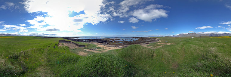
360° panorama by Brian Richards. Click the image to open the interactive version.
Near Reykjadulur Hot Spring Thermal River, Iceland. Due to the geological location of Iceland (over a rift in continental plates), the high concentration of volcanoes in the area is often an advantage in the generation of geothermal energy, the heating and making of electricity. During winter, pavements near these areas (such as Reykjavik and Akureyri) are heated up. Five major geothermal power plants exist in Iceland, which produce approximately 26.2% (2010)[2] of the nation's electricity. In addition, geothermal heating meets the heating and hot water requirements of approximately 87% of all buildings in Iceland. Apart from geothermal energy, 73.8% of the nation's electricity is generated by hydro power, and 0.1% from fossil fuels. Hydrogen sulfide (H2S) from geothermal energy may have impacted the health of Icelanders.
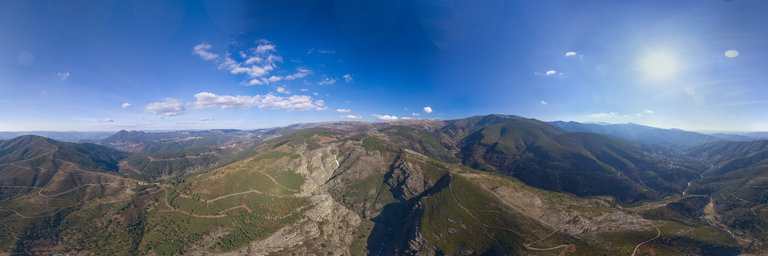
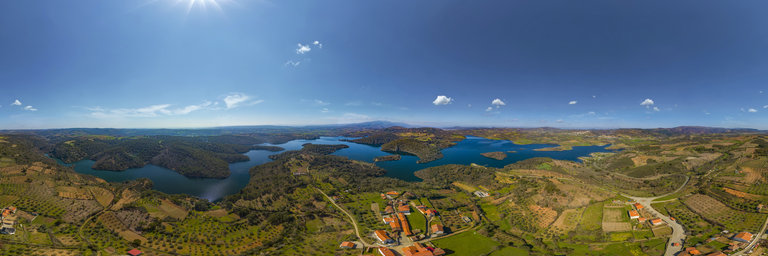
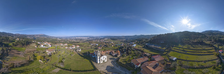
360° panorama by Santiago Ribas - 360portugal. Click the image to open the interactive version.
The Alv~ao Natural Park is a protected area in Portugal that is small in size and located between the municipalities of Mondim de Basto and Vila Real. It was created in 1983. The main geological curiosity is the waterfall known as Fisgas de Ermelo.
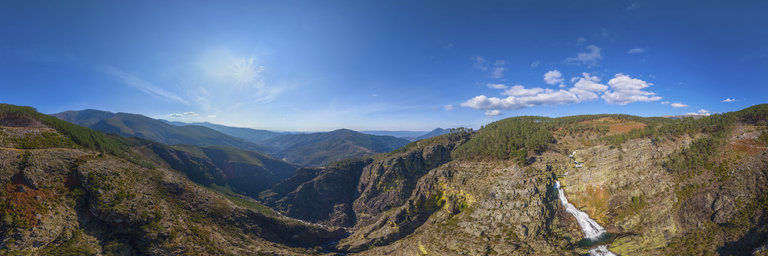
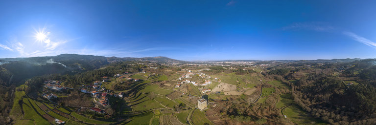
360° panorama by Santiago Ribas - 360portugal. Click the image to open the interactive version.
From the rocky lookout at the end of the road, you can see the quartzite bench where the Olo River falls, with a difference of 300m. In these fragas it was once the nesting place for one of the couples of Golden Eagles of Alv~ao. Currently, only one couple of this species remains.
360° panorama by Brian Richards. Click the image to open the interactive version.
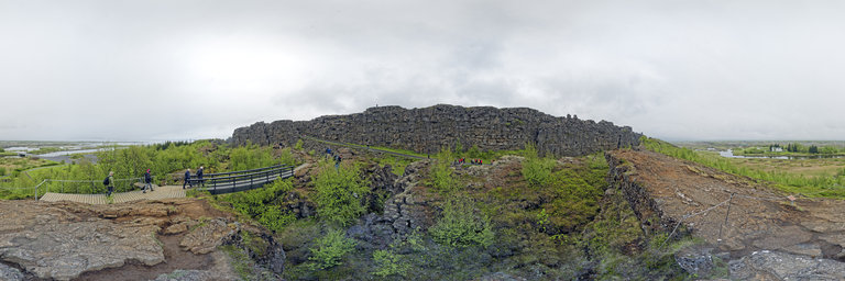
Thingvellir, anglicised as Thingvellir was the site of the Althiing, the annual parliament of Iceland from 930AD until the last session held at Thingvellir in 1798AD[2]. Since 1881, the parliament has been located within Althingish'usid in Reykjavik. Thingvellir is now a national park in the municipality of Bl'ask'ogabyggd in southwestern Iceland, about 40 km northeast of Iceland's capital, Reykjav'ik. Thingvellir is a site of historical, cultural, and geological significance, and is one of the most popular tourist destinations in Iceland. The park lies in a rift valley that marks the crest of the Mid-Atlantic Ridge and the boundary between the North American and Eurasian tectonic plates. To its south lies Thingvallavatn, the largest natural lake in Iceland. Thingvellir National Park was founded in 1930, marking the 1000th anniversary of the Althing. The park was later expanded to protect the diverse and natural phenomena in the surrounding area, and was designated as a World Heritage Site in 2004.
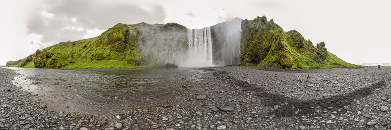
360° panorama by Brian Richards. Click the image to open the interactive version.
Sk'ogafoss is a waterfall on the Sk'og'a River in the south of Iceland at the cliff marking the former coastline. After the coastline had receded (it is now at a distance of about 5 kilometres (3 miles) from Sk'ogar), the former sea cliffs remained, parallel to the coast over hundreds of kilometres, creating together with some mountains a clear border between the coastal lowlands and the Highlands of Iceland.
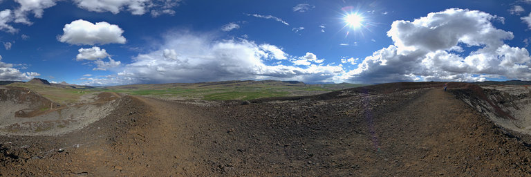
360° panorama by Brian Richards. Click the image to open the interactive version.
Gr'abr'ok crater. Highest point. Elevation, 988 m (3,241 ft). Part of the Lj'osufj"oll fissure vent system and central volcano on the Snaefellsnes Peninsula in Iceland. The system has a length of about 90 km. The volcanic system contains cinder cones and is the only system on the peninsula that has erupted in recorded history. The eruption took place in the 12th century) and cost the lives of around 80 people. One of them was the then bishop of Sk'alholt, Magn'us Einarsson. The name derives from the central volcano and translates into English as "Mountains of the Light". The system is the largest Quaternary rhyolitic outcrop in the Snaefellsnes volcanic zone and as such the central volcano is highly silicic which causes the light coloration.
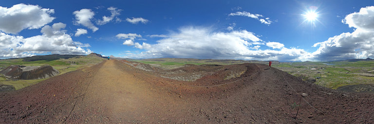
360° panorama by Santiago Ribas - 360portugal. Click the image to open the interactive version.
The route from the Santa Combinha Biodiversity Station is a circular pedestrian route, which begins and ends at the viewpoint next to the village of Santa Combinha, and which follows the Ricardo Magalh~aes Trail in 2.6 km (4.1 km total length) ) The entire route is well marked with guidance signs and information panels that will help you to identify some species of fauna and flora most common in this Biodiversity Station, as well as will certainly contribute to increase your knowledge and curiosity about the world of insects.
360° panorama by Brian Richards. Click the image to open the interactive version.
The Snaefellsnes is a peninsula situated to the west of Borgarfj"ordur, in western Iceland. It has been named Iceland in Miniature, because many national sights can be found in the area, including the Snaefellsj"okull volcano, regarded as one of the symbols of Iceland. With its height of 1446 m, it is the highest mountain on the peninsula and has a glacier at its peak. The volcano can be seen on clear days from Reykjav'ik, a distance of about 120 km. The mountain is also known as the setting of the novel Journey to the Center of the Earth by the French author Jules Verne. The area surrounding Snaefellsj"okull has been designated one of the four National Parks by the government of Iceland. The peninsula is one of the main settings in the Laxdoela saga and it was, according to this saga, the birthplace of the first West Norse member of the Varangian Guard, Bolli Bollasson. Other historical people who lived in the area according to the saga include Gudr'un 'Osv'ifursd'ottir, Bolli Thorleiksson and Snorri Godi.
360° panorama by Santiago Ribas - 360portugal. Click the image to open the interactive version.
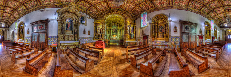
The Church of Santiago de Mondr~oes was built in the first decades of the 16th century (Reign of D. Manuel I), when it benefited from the Manueline charter of the neighboring municipality of Penagui~ao. It is a temple dedicated to Santiago, with a single nave, with proportions width x height x depth typical of Manueline temples. Its Baroque exterior, the result of a 1744 reconstruction, hides a Manueline interior, with a nave with four uneven sections, marked by framed Tuscan pilasters, covered by starred vaults based on gummed corbels and decorated with different motifs. In 1721 it belonged to the patronage of the religious of S~ao Jer'onimo do Mosteiro de Bel'em, which presents it with the title of guardian, and is attached to the Matrix of the Savior of Torgueda; he had a Brotherhood of Souls and four Confraternities, that of Nossa Senhora do Ros'ario, that of the Holy Name of Jesus, that of S~ao Sebasti~ao and that of Santiago, with the respective altars manufactured from what was necessary through alms.
360° panorama by Santiago Ribas - 360portugal. Click the image to open the interactive version.
The first reference to the Quintela Tower appears in the Inquiries of D. Afonso III, in 1258; at the end of the 17th century, the forums and deadlines received by its lord, the Count of Vimioso, are recorded in Tombo da Torre de Quintela. This document contains information that clearly indicates that, in addition to the tower, the estate was composed of other buildings, namely a chapel in honor of Santa Maria Madalena, and a terrace located between the two buildings. At the beginning of the 20th century, its disappearance was imminent, but, because it was too expensive for its owner to dismantle it, to use the stone, this did not happen. In 1910 it was classified as a National Monument, and in 1982 it underwent restoration work that gave it its current appearance.
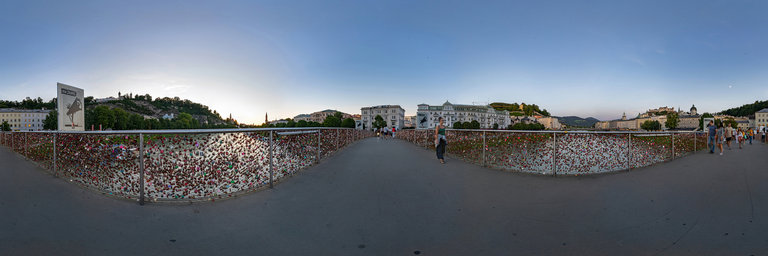
360° panorama by flaviodmt76. Click the image to open the interactive version.
The Feingold-Steg, which was called Makartsteg until autumn 2020, is a bridge for pedestrians and cyclists over the Salzach in the city of Salzburg.photo: Voigtlander 12mm original size 17000x8500www.abagontheroad.com
360° panorama by Santiago Ribas - 360portugal. Click the image to open the interactive version.
This Palace is a rural palatial house with a rectangular plan, divided into two hollow squares in the central area, thus creating several wings, composing two patios that are connected to each other through large openings on the ground floor. While the backyard is closed, the front yard is open, thus allowing the view of the main facade which is set back and facing west. To access the noble floor, there are double staircases repeated on the transversal facades of both patios, one to the east and two to the west, which makes the symmetry and the Baroque movement of the entire ornamentation even more accentuated.
360° panorama by Santiago Ribas - 360portugal. Click the image to open the interactive version.
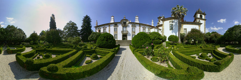
Mateus Palace, in Vila Real, is one of the most famous monuments in the whole world, through its image on the labels of a well-known wine brand. It will have started during the 1st quarter of the 16th century, when the marriage between Maria 'Alvares (descendant of the owners of Quinta da Cumieira) and 'Alvaro Coelho, owner of the lands of S.Martinho de Mateus. The so-called Casa das Adegas (north facade of Solar) is built. In the 17th century, a house was built on the site where the Palace currently stands. In 1641 Ant'onio 'Alvares Coelho marries his second cousin, D. Helena 'Alvares Mour~ao, and institutes Morgado de Mateus (Morgado or morgadio is a form of family organization that creates a lineage, as well as a code to designate his successors, statutes and behaviors), linked to the Chapel of Na Sra dos Prazeres in Quinta de Mateus. Between 1670 and 1720, the original house was renovated, reformed for the Palace, but it will be demolished, and replaced between 1739-1743 by the current Mateus Palace, according to the intervention of the architect Nicolau Nazoni. According to tradition, the gardens were designed and planted in the early 18th century by Diogo 'Alvares Botelho Mour~ao (1673 - 1744). It is also in the mid-18th century that the 3rd Morgado D. Luis Ant'onio de Sousa Botelho, asks the Archbishop of Braga for authorization to build a new Chapel (the current one), in a building away from the existing houses, replacing an earlier, smaller one, and attached to the Palace.
360° panorama by Santiago Ribas - 360portugal. Click the image to open the interactive version.
The Church of S~ao Pedro is one of the best religious examples of the Baroque style in Vila Real. The original building, built in 1528, has undergone changes of various kinds over time, until it has the form it now takes. Among these changes, most of them made in the 18th century (hence the Baroque style) are the main chapel tiles, the introduction of panels on the ceiling, and the construction of the facade. In addition to the richness of the interior, there is the abundant decoration of the facade, with two imposing bell towers, which make this Church the only example of this type in the historic center of Vila Real.
Понедельник, 21 Сентября 2020 г. 21:52
+ в цитатник
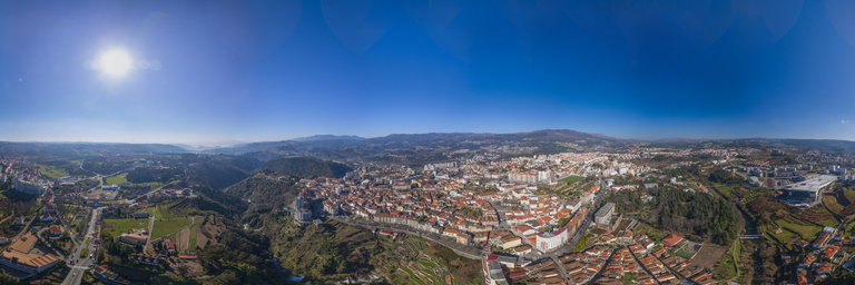
360° panorama by Santiago Ribas - 360portugal. Click the image to open the interactive version.
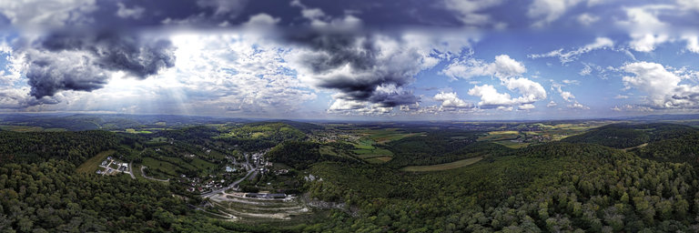
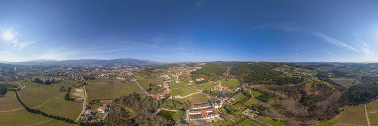
Vila Velha is a promontory between the Corgo and Cabril rivers, where the city was born. The site is characterized by the uniqueness of its location, a promontory over the landscape, of great landscape quality, as well as by its archaeological importance, relevant to the development of the city.
Понедельник, 21 Сентября 2020 г. 21:49
+ в цитатник
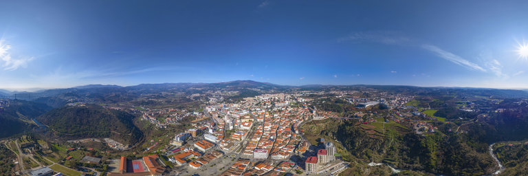
360° panorama by Santiago Ribas - 360portugal. Click the image to open the interactive version.
Blacksmiths' neighborhood. Part of the historic area of the city, albeit marginal, due to the geographical situation. It developed to the left bank of the Corgo River, through the connection of the Ponte de Santa Margarida, and later with the construction of the railway line, and metallic bridge.