Nevada: 27 SF-SL Coal Canyon airway beacon (aerial)
|
|
Суббота, 19 Июня 2021 г. 04:37
+ в цитатник
360° panorama by
William l.
Click the image to open the interactive version.
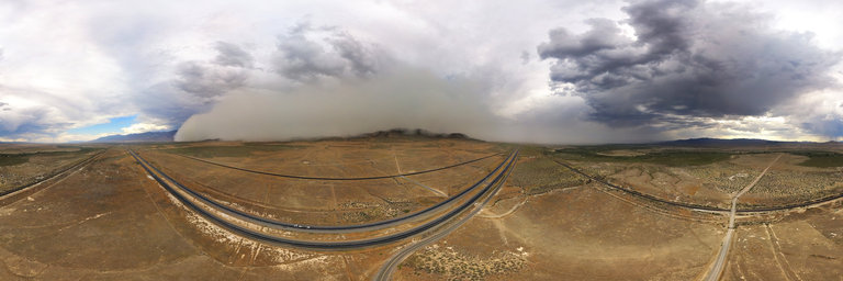
A 400' aerial view within the Upper Valley just northeast of Lovelock, Nevada. Here one can see a giant dust storm (haboob) formed from thunderstorms & winds originating from the Reno area. Having come from that way, I had driven through it as it was quite gusty, most of the dust picked up early on & especially arising from the dry Humboldt Sink. As you can see it is crossing over mountains range & was a good mile in height. It was relatively calm in the view, yet about two minutes later it arrived & turned everything into a gusty fog. Directly below one can see an arrow, part of the arrow & beacon airmail system. Before our current GPS satellite & radar, airplane pilots who did transcontinental airmail routes at night would fly following these large cement arrows, often accompanied by beacons with a light. While there were over 1500 of them across the country back in the day, about 100 of them remain today, decaying & forgotten like this one. This one is along the San Francisco to Salt Lake City airway, to which the route was established on September 8, 1920 & discontinued on November 30, 1930.
http://www.360cities.net/image/coal
-
Запись понравилась
-
0
Процитировали
-
0
Сохранили
-


