Добавить любой RSS - источник (включая журнал LiveJournal) в свою ленту друзей вы можете на странице синдикации.
Исходная информация - http://www.360cities.net/. Данный дневник сформирован из открытого RSS-источника по адресу http://www.360cities.net/rss/rss.xml, и дополняется в соответствии с дополнением данного источника. Он может не соответствовать содержимому оригинальной страницы. Трансляция создана автоматически по запросу читателей этой RSS ленты. По всем вопросам о работе данного сервиса обращаться со страницы контактной информации.[Обновить трансляцию]
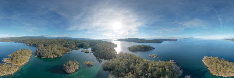
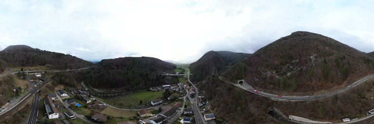
360° panorama by Robert Prior. Click the image to open the interactive version.
Smuggler Cove, Secret Cove, Pirate Rock, Buccaneer Bay (oops! not that one) owe their names to rum-runners and smugglers who used the captivating landscape along the Sunshine Coast as hiding places. Leather, livestock, liquor, opium, and people were smuggled from British Columbia to Washington State. One of the most famous true tales tells us that Smuggler Cove owes its name to Pirate Lawrence (Larry) Kelly, “King of the Smugglers”. Kelly came up to Canada after fighting in the American Civil War. When the building of Canadian Pacific Railway was complete, many unemployed Chinese workers tried to emigrate to the United States but were forbidden official entry. Pirate Kelly ferried them across the border for a fee of $100 each. His horrific insurance against detection was to have them agree to be roped together and tied to a large hunk of crude iron. In the event of apprehension by U.S. customs, he would throw the iron and his clients overboard. (Whether he actually did it or not is uncertain.) Larry Kelly smuggled opium and people from 1865 until he retired in 1911 evading arrest (sometimes) by hiding in Smuggler Cove. He was known for his skill at the helm of a sailboat, and was well acquainted with most of the jails in Washington State.Pirate Kelly’s main ‘trade’ was opium; legal back then, but taxable. He would run opium in an illicit dash through the San Juan Islands to Pt. Townsend, where he’d land at night and let opium down the chimneys of Chinese laundries.The “King of the Smugglers” married Lizzie Cootes/Katz in 1878 and had a tumultuous relationship, not helped by Larry’s frequent visits to various jails. When the final break-up occurred, Lizzie and her children moved to Anacortes, Washington. Eventually Larry was believed to have moved to Louisiana but no record of him has ever been found.Or maybe he paid a visit to Davey Jones’s locker? (From an article in the Oracle.)
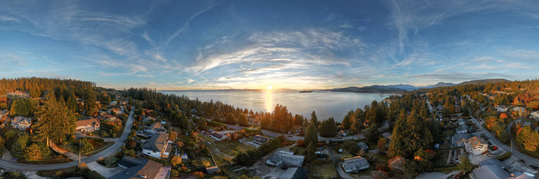
360° panorama by Robert Prior. Click the image to open the interactive version.
Sunsets can be spectacular on British Columbia’s Sunshine Coast. Selma Park is a residential district in Sechelt, about halfway between downtown Sechelt and Davis Bay. To the north you can see Sechelt proper.
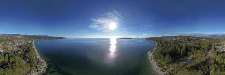
360° panorama by Robert Prior. Click the image to open the interactive version.
Sunsets can be spectacular on British Columbia’s Sunshine Coast. Selma Park is a residential district in Sechelt, about halfway between downtown Sechelt and Davis Bay. To the north you can see Sechelt proper.
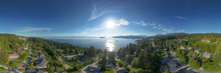
360° panorama by Robert Prior. Click the image to open the interactive version.
Sechelt (ch’atlich) is located on the traditional territory of the sh'ish'alh (Sechelt) Nation. It’s the name of a people, a community, a peninsula, and an inlet. The community of almost 11,000 people sits on a narrow isthmus that separates the Sechelt Inlet from the Salish Sea. To get to Sechelt, you must take a 40-minute ferry ride from Horseshoe Bay to Langdale (and either drive, bike, or take transit along Highway 101 for the remainder of the way), travel via float plane, or navigate by boat. Surrounded by coastline and forests, Sechelt serves as a fantastic adventure hub for people of every level of ambition and ability. There is also a bustling arts scene full of many skilled artisans, performers, and other creatives. Stop by the Sechelt Visitor Centre to learn about attractions in the area, check out your transportation options, and get up-to-date local insights from friendly experts. The Visitor Centre is surrounded by gardens and has its own courtyard complete with a water feature, making it a nice respite after a long car ride. It’s also a great place to pick up souvenirs! Within walking distance from the Visitor Centre you’ll find Trail Bay Mall, Sechelt Aquatic Centre, the Sechelt Seawall, and Cowrie Street—the main shopping street in Downtown Sechelt. You can also access local public transit and other shuttle services along Cowrie Street.
360° panorama by Robert Prior. Click the image to open the interactive version.
Selma Park is a housing development in Sechelt, British Columbia. Sechelt (ch’atlich) is located on the traditional territory of the sh'ish'alh (Sechelt) Nation. It’s the name of a people, a community, a peninsula, and an inlet. The community of almost 11,000 people sits on a narrow isthmus that separates the Sechelt Inlet from the Salish Sea. To get to Sechelt, you must take a 40-minute ferry ride from Horseshoe Bay to Langdale (and either drive, bike, or take transit along Highway 101 for the remainder of the way), travel via float plane, or navigate by boat. Surrounded by coastline and forests, Sechelt serves as a fantastic adventure hub for people of every level of ambition and ability. There is also a bustling arts scene full of many skilled artisans, performers, and other creatives.
360° panorama by Robert Prior. Click the image to open the interactive version.
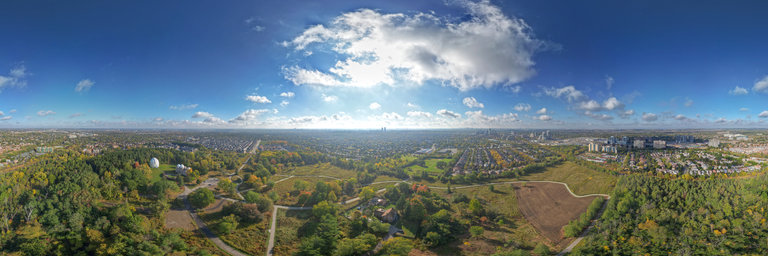
The Richmond Hill David Dunlap Observatory (RHDDO) houses the largest telescope in Canada. A number of important studies have taken place here, including providing the first direct evidence that Cygnus X-1 was a black hole, pioneering measurements of the distance to globular clusters and the discovery that Polaris was stabilizing. In 2019 it was recognized as a National Historic Site.
360° panorama by Robert Prior. Click the image to open the interactive version.
The Richmond Hill David Dunlap Observatory (RHDDO) houses the largest telescope in Canada. A number of important studies have taken place here, including providing the first direct evidence that Cygnus X-1 was a black hole, pioneering measurements of the distance to globular clusters and the discovery that Polaris was stabilizing. In 2019 it was recognized as a National Historic Site.
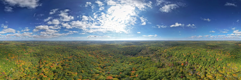
360° panorama by Robert Prior. Click the image to open the interactive version.
A view over the second-growth forest at the East Duffins Headwaters conservation lands. The forest is just beginning to change colour, and you can see the recreation trails winding through the meadows.