Добавить любой RSS - источник (включая журнал LiveJournal) в свою ленту друзей вы можете на странице синдикации.
Исходная информация - http://www.360cities.net/. Данный дневник сформирован из открытого RSS-источника по адресу http://www.360cities.net/rss/rss.xml, и дополняется в соответствии с дополнением данного источника. Он может не соответствовать содержимому оригинальной страницы. Трансляция создана автоматически по запросу читателей этой RSS ленты. По всем вопросам о работе данного сервиса обращаться со страницы контактной информации.[Обновить трансляцию]
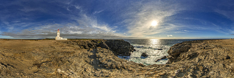
360° panorama by Lennart Borjeson. Click the image to open the interactive version.
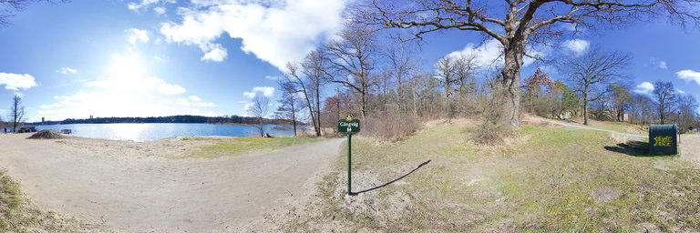
Brunnsvikens strandbad is one of the City of Stockholm's 31 official beach baths. The bath is located near Frescati at Brunnsviken on Norra Djurgarden.
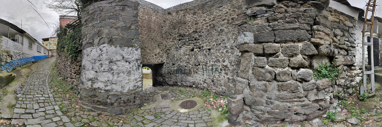
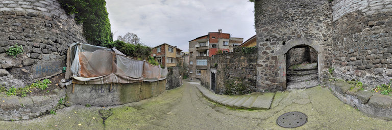
360° panorama by Halil TERZI. Click the image to open the interactive version.
The Walls of Trabzon (or the "Walls of Trebizond") are a series of defensive walls surrounding the old town of the city of Trabzon, northeastern Turkey. The fortifications are sometimes called the Trabzon Castle (Turkish: Trabzon Kalesi). However, they did not function as a castle, rather as city walls. Constructed on foundations dating back to the Roman era with cut stones from former structures at site, the walls stretch from the hill on the backside of the old town to the Black Sea shore. The walls further divided the city into three parts; the Upper Town or "fortress" (Yukari Hisar), the Middle Town (Orta Hisar) and the Lower Town (Asagi Hisar). The upper and middle towns are flanked by steep ravines cut by the Zagnos (Iskeleboz) and Tabakhane (Kuzgun) streams to the west and east respectively, while the lower town extends to the west of Zagnos (see the plan on the right). The citadel The Upper Town functioned as the citadel and as the acropolis of the city. It is believed that the citadel was built as the first construction in 2000 BC. Some early sources mention the existence of ruins of structures such as hippodrome, tower, bath and palace. The citadel underwent various modifications in the history. The walls of the Upper Fortress are higher than of the other parts. It is fortified in the south with higher and thicker walls and towers. During the Roman period an aqueduct was built to supply the Upper Town with a freshwater source. The Upper Town was accessible through a double gate with the Middle Town. The imperial palace of the Empire of Trebizond was located in the Upper Town. After the surrender of the city to Ottoman forces a small mosque was built next to the palace. Some epigraphs from Ottoman era, which were found between the citadel walls, can be seen in Trabzon Museum. The Middle Town, which was built by Alexios II of Trebizond (reigned 1297–1330), is the continuation of the upper and lower parts. It has no regular form. Its two gates, Imaret Kapi (literally: Alms Kitchen Gate) and Zaganos Kapi (Zaganos Pasha Gate) are situated in the west. It has two more gates at other sides, Tabakhane Kapisi (Tannery Gate) and Kule Kapi (Tower Gate). Notable buildings found here are Orta Hisar Mosque (Panagia Chrysocephalos Church), Governor's mansion, Zaganos Bridge, Kule Hamami (Tower Bath), Cifte Hamma (Twin Bath), Amasya Mosque, Sirin Hatun Mosque and Musa Pasha Mosque. The Lower Town stretches in the west from Zaganos Tower down to the sea. Also this part of the fortifications were built by Alexios II of Trebizond. However, an inscription with the tughra of Ottoman sultan Mehmed II (reigned 1444–46 and 1451–81) is situated above the gate in the Moloz Tabya (literally: Rubble Bastion). In the east, there are two gates, Pazarkapi (Marketplace Gate) and Mumhane Kapi (Chandlery Gate). Historical buildings around the Lower Fortress are Molla Siyah Mosque (St. Andreas Church), Hoca Halil Mosque, Pazarkapi Mosque, Kundupoglu and Yarimbiyikoglu manions, Sekiz D"uzenli Hamam (bath), Tophane Hamami (bath), Haci Arif Hamami (bath) and Iskender Pasha fountains. The most of the city walls are still standing and are among the city's oldest buildings. In fact, their oldest part can be dated back to 1st century AD during the Roman Empire era. Historical sources provide information about older stages of their construction. Xenophon, who visited the city in 5th century BC also mentioned the existence of city walls. In 1921, some of the remaining Christians of the city were ordered by the municipal authorities to dismantle the stone of the Comnenos era fortress and use the rubble for road building. During the 20th century the valleys on both the western and eastern sides of the middle and upper towns were built up with illegal constructions, in some cases obstructing the view of the walls. In the last two decades the municipality of Trabzon has initiated a series of redevelopment projects surrounding the old town. As of 2017 the western Zagnos valley has been turned into a park with unobstructed view of the walls and aqueduct, and the illegal constructions in the eastern Kuzgun (or Tabakhane) valley have been torn down. Kuzgun valley will eventually also be turned into a park. Source: https://en.wikipedia.org/wiki/Walls_of_Trabzon
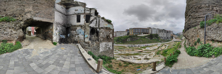
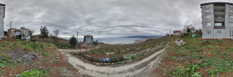
360° panorama by Andrew Bodrov. Click the image to open the interactive version.
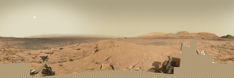
NASA's Mars Exploration Program (Image credit: NASA/JPL-Caltech/MSSS) Sol 3090: No MAHLI Today The images for panorama obtained by the rover's 34-millimeter Mast Camera. The mosaic, which stretches about 30,000 pixels width, includes 121 images taken on Sol 3090 (April 15, 2021). The Sol 3088 drive went well, and there is lots of bedrock in the arm workspace. The strategic plan included full contact science to support selection of the next drill target, but unfortunately the Sol 3088 MAHLI activities did not complete as expected, so no MAHLI imaging is planned today while the team evaluates MAHLI telemetry. But we're still planning to brush a bedrock target named "Bardou" and observe the brushed spot and a nearby unbrushed spot with APXS, to help understand the compositions of the bedrock, dust, and sand in the area. Before deploying the arm, a passive ChemCam observation of Bardou is planned, along with RMI mosaics of distant targets on the flank of "Mt. Sharp" and what appears to be a windblown drift deposit near the top of "Mont Mercou." Later in the afternoon of Sol 3090, the Left Mastcam will acquire a full 360-degree mosaic, which is likely to provide a spectacular view. After the arm is moved out of the way late in the morning of Sol 3091, Navcam and Mastcam will measure the amount of dust suspended in the atmosphere, then Mastcam will acquire a multispectral observation of the brushed spot and stereo mosaics of "Mini Mont Mercou" and a ridge in the distance toward the southwest. Finally, the Left Mastcam will survey the sky for clouds during twilight. Ken Herkenhoff Research Geologist at the USGS Astrogeology Science Center and a member of the MSL science team Other panoramas of Mars by Curiosity rover: http://www.360cities.net/sets/curiosity-mars
360° panorama by Andrew Bodrov. Click the image to open the interactive version.
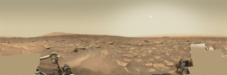
NASA's Mars Exploration Program (Image credit: NASA/JPL-Caltech/MSSS) Sol 1688: Sand between our grousers The images for panorama obtained by the rover's 34-millimeter Mast Camera. The mosaic, which stretches about 30,000 pixels width, includes 122 images taken on Sol 1688 (May 5, 2017). Today was a Friday so we put together a three day plan to cover the weekend activities, or in Mars-speak, sols 1688 - 1690. We've been getting some really interesting data down from our investigation of a large sand drift (megaripple), so we packed in many more observations to assess the full variability of the sandy materials before driving away and continuing our climb up Mt. Sharp. Over the weekend, we are planning to take APXS and MAHLI observations that focus on the materials inside the area of sand that was scuffed by the wheel ("Little Notch"), and also some bright undisturbed materials ("Cold Ledge"). We will also take MAHLI only observations of different undisturbed portions of the megaripple at "Schoolhouse Ledge" and "Man of War Brook". In addition to contact science, we will take many Mastcam images, including a full 360-degree mosaic, a mosaic of our future drive target ("Buttermilk Brook"), a multispectral observation of some vein targets ("Eddie Brook"), and images of a handful of interesting nearby rocks ("Little Harbor Brook", "Bubble Brook", and "Marshall Brook.") We're rounding out remote sensing observations in the plan with ChemCam observations of "Stanley Brook", "Chasm Brook", and "Denning Brook", and a post-drive automated ChemCam AEGIS activity. The environmental theme group also included a dust devil survey, measurements of dust in the atmosphere, and horizon movies. For tactical planning today, I was again staffed as a Surface Properties Scientist (SPS), so I worked closely with the rover planners (RPs) to help plan the drive to an interesting location ~20 meters away. We can see in the Mastcam images that there are some rocks that have colors and textures different from the typical outcrops we've been seeing during the majority of our ascent, so the science team is eager to drive over and check out this area up close. I look forward to seeing our new location Monday morning when the data come down. Abigail Fraeman Planetary Geologist at NASA's Jet Propulsion Laboratory Other panoramas of Mars by Curiosity rover: http://www.360cities.net/sets/curiosity-mars
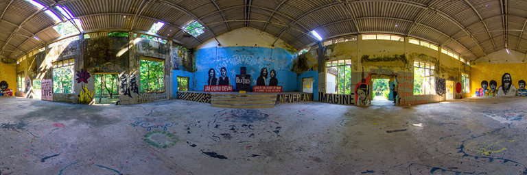
360° panorama by BeeVR Studio. Click the image to open the interactive version.
This is the main hall, also known as the Satsang Hall (EVENT HALL) at the Beatles Ashram in India. This ashram is also known as the Maharishi Mahesh Yogi Ashram which The Beatles visited in 1960's to learn the renowned Trancendental Meditation technique. This is located in Rishikesh by the River Ganges in North India. SEE IN VR TO ENJOY DEPTH ( stereoscopic ) view.
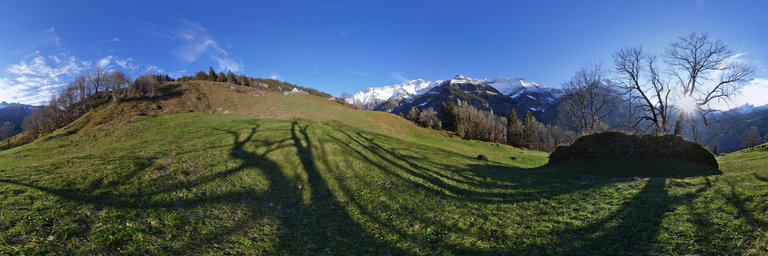
360° panorama by C K. Click the image to open the interactive version.
Nach einen paar sch"onen Fl"ugen am sp"aten Sonntagnachmittag noch schnell ein Panormamabild vom Platz des FVS Dreieich geschossen. Verwendete Ausr"ustung: Panasonic Lumix S5 mit 16-35mm F4.